You are here: Home > Network List > AV - Alaska Volcano Observatory Stations List
> Station WESP Westdahl Peak, Westdahl Peak, Alaska > Earthquake Result Viewer
WESP Westdahl Peak, Westdahl Peak, Alaska - Earthquake Result Viewer
| Earthquake location: |
Eastern New Guinea Reg., P.N.G. |
| Earthquake latitude/longitude: |
-6.2/146.5 |
| Earthquake time(UTC): |
2022/09/10 (253) 23:46:55 GMT |
| Earthquake Depth: |
61 km |
| Earthquake Magnitude: |
7.6 mww |
| Earthquake Catalog/Contributor: |
NEIC PDE/us |
|
| Network: |
AV Alaska Volcano Observatory |
| Station: |
WESP Westdahl Peak, Westdahl Peak, Alaska |
| Lat/Lon: |
54.49 N/164.72 W |
| Elevation: |
937 m |
|
| Distance: |
72.9 deg |
| Az: |
27.346 deg |
| Baz: |
231.52 deg |
| Ray Param: |
0.053256936 |
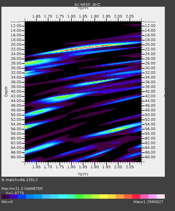
| Estimated Moho Depth: |
21.0 km |
| Estimated Crust Vp/Vs: |
1.88 |
| Assumed Crust Vp: |
5.989 km/s |
| Estimated Crust Vs: |
3.19 km/s |
| Estimated Crust Poisson's Ratio: |
0.30 |
|
| Radial Match: |
96.32913 % |
| Radial Bump: |
400 |
| Transverse Match: |
93.12681 % |
| Transverse Bump: |
400 |
| SOD ConfigId: |
28764291 |
| Insert Time: |
2022-09-24 23:56:00.862 +0000 |
| GWidth: |
2.5 |
| Max Bumps: |
400 |
| Tol: |
0.001 |
|

Signal To Noise
| Channel | StoN | STA | LTA |
| AV:WESP: :BHZ:20220910T23:57:46.639005Z | 9.775788 | 6.2543013E-6 | 6.397746E-7 |
| AV:WESP: :BHN:20220910T23:57:46.639005Z | 2.4621212 | 2.2634467E-6 | 9.193076E-7 |
| AV:WESP: :BHE:20220910T23:57:46.639005Z | 2.5938027 | 2.8355432E-6 | 1.0931993E-6 |
| Arrivals |
| Ps | 3.2 SECOND |
| PpPs | 9.8 SECOND |
| PsPs/PpSs | 13 SECOND |


