You are here: Home > Network List > US - United States National Seismic Network Stations List
> Station MVCO Mesa Verde, Colorado, USA > Earthquake Result Viewer
MVCO Mesa Verde, Colorado, USA - Earthquake Result Viewer
| Earthquake location: |
Haiti Region |
| Earthquake latitude/longitude: |
18.4/-72.6 |
| Earthquake time(UTC): |
2010/01/12 (012) 21:53:10 GMT |
| Earthquake Depth: |
13 km |
| Earthquake Magnitude: |
6.8 MB, 7.3 MS, 7.0 MW, 7.0 MW |
| Earthquake Catalog/Contributor: |
WHDF/NEIC |
|
| Network: |
US United States National Seismic Network |
| Station: |
MVCO Mesa Verde, Colorado, USA |
| Lat/Lon: |
37.21 N/108.50 W |
| Elevation: |
2170 m |
|
| Distance: |
36.6 deg |
| Az: |
308.177 deg |
| Baz: |
110.822 deg |
| Ray Param: |
0.07659709 |
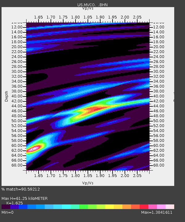
| Estimated Moho Depth: |
61.25 km |
| Estimated Crust Vp/Vs: |
1.62 |
| Assumed Crust Vp: |
6.476 km/s |
| Estimated Crust Vs: |
3.985 km/s |
| Estimated Crust Poisson's Ratio: |
0.20 |
|
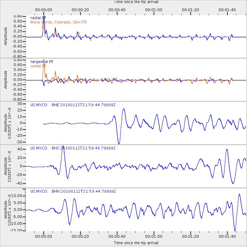
| Radial Match: |
90.59212 % |
| Radial Bump: |
297 |
| Transverse Match: |
73.47435 % |
| Transverse Bump: |
400 |
| SOD ConfigId: |
1 |
| Insert Time: |
2010-03-17 21:12:25.856 +0000 |
| GWidth: |
2.5 |
| Max Bumps: |
400 |
| Tol: |
0.001 |
|
Signal To Noise
| Channel | StoN | STA | LTA |
| US:MVCO: :BHZ:20100112T21:59:44.79999Z | 1.5370305 | 1.0906558E-6 | 7.0958635E-7 |
| US:MVCO: :BHN:20100112T21:59:44.79999Z | 1.2809001 | 8.3232E-7 | 6.4979304E-7 |
| US:MVCO: :BHE:20100112T21:59:44.79999Z | 0.9377688 | 5.917392E-7 | 6.3100754E-7 |
| Arrivals |
| Ps | 6.4 SECOND |
| PpPs | 23 SECOND |
| PsPs/PpSs | 29 SECOND |


