You are here: Home > Network List > CI - Caltech Regional Seismic Network Stations List
> Station MPP McPhearson Peak > Earthquake Result Viewer
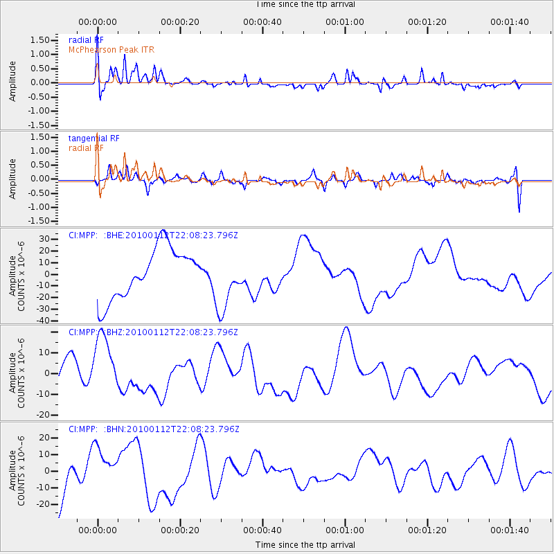
MPP McPhearson Peak - Earthquake Result Viewer
*The percent match for this event was below the threshold and hence no stack was calculated.
| Earthquake location: |
Haiti Region |
| Earthquake latitude/longitude: |
18.4/-72.8 |
| Earthquake time(UTC): |
2010/01/12 (012) 22:00:41 GMT |
| Earthquake Depth: |
10 km |
| Earthquake Magnitude: |
6.0 MB |
| Earthquake Catalog/Contributor: |
WHDF/NEIC |
|
| Network: |
CI Caltech Regional Seismic Network |
| Station: |
MPP McPhearson Peak |
| Lat/Lon: |
34.89 N/119.81 W |
| Elevation: |
1739 m |
|
| Distance: |
44.7 deg |
| Az: |
301.25 deg |
| Baz: |
99.061 deg |
| Ray Param: |
$rayparam |
*The percent match for this event was below the threshold and hence was not used in the summary stack. |
|
| Radial Match: |
70.77078 % |
| Radial Bump: |
400 |
| Transverse Match: |
63.66844 % |
| Transverse Bump: |
400 |
| SOD ConfigId: |
1 |
| Insert Time: |
2010-03-17 21:14:58.463 +0000 |
| GWidth: |
2.5 |
| Max Bumps: |
400 |
| Tol: |
0.001 |
|
Signal To Noise
| Channel | StoN | STA | LTA |
| CI:MPP: :BHZ:20100112T22:08:23.796Z | 2.568596 | 1.5081067E-5 | 5.871327E-6 |
| CI:MPP: :BHN:20100112T22:08:23.796Z | 0.7791003 | 1.14113645E-5 | 1.4646849E-5 |
| CI:MPP: :BHE:20100112T22:08:23.796Z | 1.1747429 | 2.5177358E-5 | 2.1432228E-5 |
| Arrivals |
| Ps | |
| PpPs | |
| PsPs/PpSs | |


