You are here: Home > Network List > TA - USArray Transportable Network (new EarthScope stations) Stations List
> Station M22A Cedar Creek Ranch, Saratoga, WY, USA > Earthquake Result Viewer
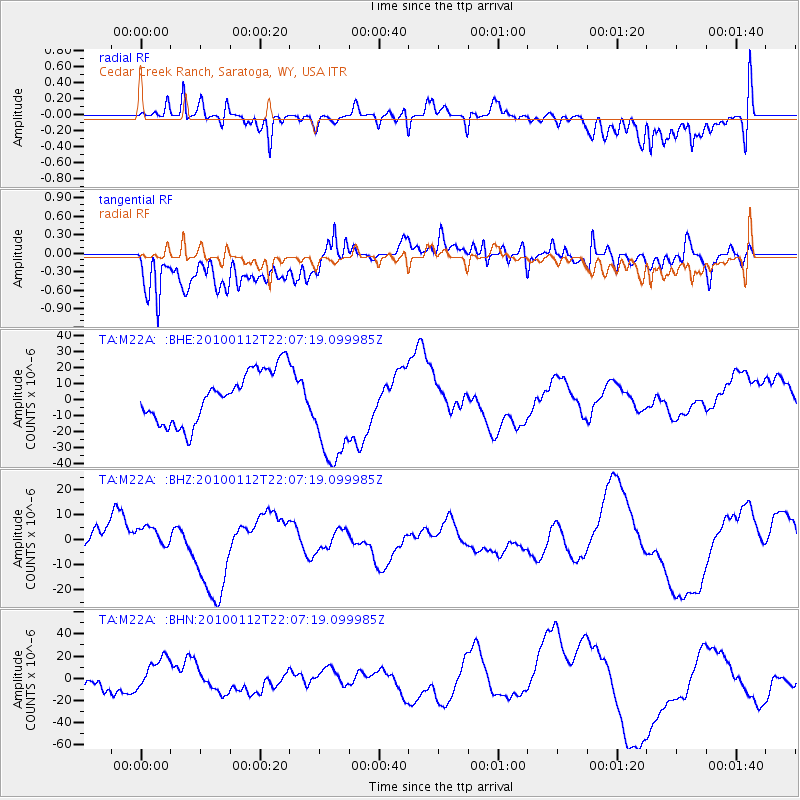
M22A Cedar Creek Ranch, Saratoga, WY, USA - Earthquake Result Viewer
*The percent match for this event was below the threshold and hence no stack was calculated.
| Earthquake location: |
Haiti Region |
| Earthquake latitude/longitude: |
18.4/-72.8 |
| Earthquake time(UTC): |
2010/01/12 (012) 22:00:41 GMT |
| Earthquake Depth: |
10 km |
| Earthquake Magnitude: |
6.0 MB |
| Earthquake Catalog/Contributor: |
WHDF/NEIC |
|
| Network: |
TA USArray Transportable Network (new EarthScope stations) |
| Station: |
M22A Cedar Creek Ranch, Saratoga, WY, USA |
| Lat/Lon: |
41.40 N/106.60 W |
| Elevation: |
2334 m |
|
| Distance: |
36.9 deg |
| Az: |
315.746 deg |
| Baz: |
118.253 deg |
| Ray Param: |
$rayparam |
*The percent match for this event was below the threshold and hence was not used in the summary stack. |
|
| Radial Match: |
59.849136 % |
| Radial Bump: |
400 |
| Transverse Match: |
58.68371 % |
| Transverse Bump: |
400 |
| SOD ConfigId: |
1 |
| Insert Time: |
2010-03-17 21:17:23.708 +0000 |
| GWidth: |
2.5 |
| Max Bumps: |
400 |
| Tol: |
0.001 |
|
Signal To Noise
| Channel | StoN | STA | LTA |
| TA:M22A: :BHZ:20100112T22:07:19.099985Z | 1.0321612 | 5.028921E-6 | 4.872224E-6 |
| TA:M22A: :BHN:20100112T22:07:19.099985Z | 1.6611189 | 1.5186569E-5 | 9.1423735E-6 |
| TA:M22A: :BHE:20100112T22:07:19.099985Z | 2.0465624 | 3.318915E-5 | 1.6217024E-5 |
| Arrivals |
| Ps | |
| PpPs | |
| PsPs/PpSs | |


