You are here: Home > Network List > CN - Canadian National Seismograph Network Stations List
> Station TAHB Tahsis, BC, CA > Earthquake Result Viewer
TAHB Tahsis, BC, CA - Earthquake Result Viewer
| Earthquake location: |
Eastern New Guinea Reg., P.N.G. |
| Earthquake latitude/longitude: |
-6.2/146.5 |
| Earthquake time(UTC): |
2022/09/10 (253) 23:46:55 GMT |
| Earthquake Depth: |
61 km |
| Earthquake Magnitude: |
7.6 mww |
| Earthquake Catalog/Contributor: |
NEIC PDE/us |
|
| Network: |
CN Canadian National Seismograph Network |
| Station: |
TAHB Tahsis, BC, CA |
| Lat/Lon: |
49.89 N/126.68 W |
| Elevation: |
455 m |
|
| Distance: |
92.7 deg |
| Az: |
40.277 deg |
| Baz: |
263.603 deg |
| Ray Param: |
0.041388404 |
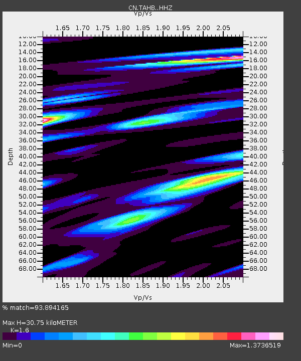
| Estimated Moho Depth: |
30.75 km |
| Estimated Crust Vp/Vs: |
1.60 |
| Assumed Crust Vp: |
6.24 km/s |
| Estimated Crust Vs: |
3.9 km/s |
| Estimated Crust Poisson's Ratio: |
0.18 |
|
| Radial Match: |
93.894165 % |
| Radial Bump: |
362 |
| Transverse Match: |
86.81529 % |
| Transverse Bump: |
400 |
| SOD ConfigId: |
28764291 |
| Insert Time: |
2022-09-25 00:01:12.169 +0000 |
| GWidth: |
2.5 |
| Max Bumps: |
400 |
| Tol: |
0.001 |
|

Signal To Noise
| Channel | StoN | STA | LTA |
| CN:TAHB: :HHZ:20220910T23:59:29.079984Z | 12.727717 | 3.5695707E-6 | 2.8045648E-7 |
| CN:TAHB: :HHN:20220910T23:59:29.079984Z | 3.076081 | 7.2461455E-7 | 2.355642E-7 |
| CN:TAHB: :HHE:20220910T23:59:29.079984Z | 4.165361 | 1.3382889E-6 | 3.2129003E-7 |
| Arrivals |
| Ps | 3.0 SECOND |
| PpPs | 13 SECOND |
| PsPs/PpSs | 16 SECOND |


