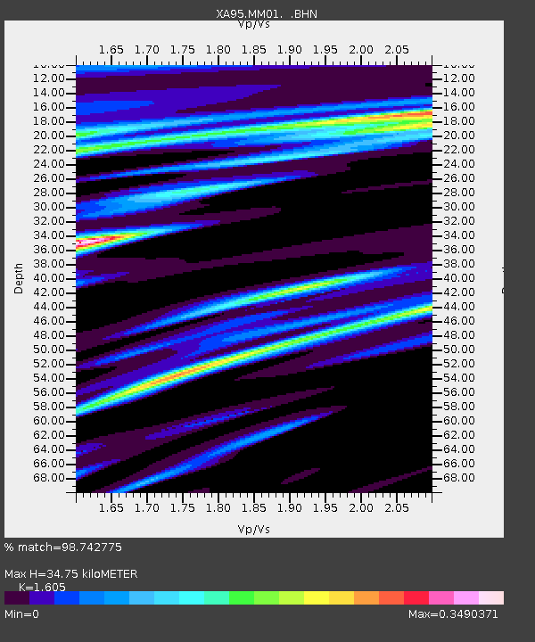
MM01 North Hampton, Massachusetts - Earthquake Result Viewer
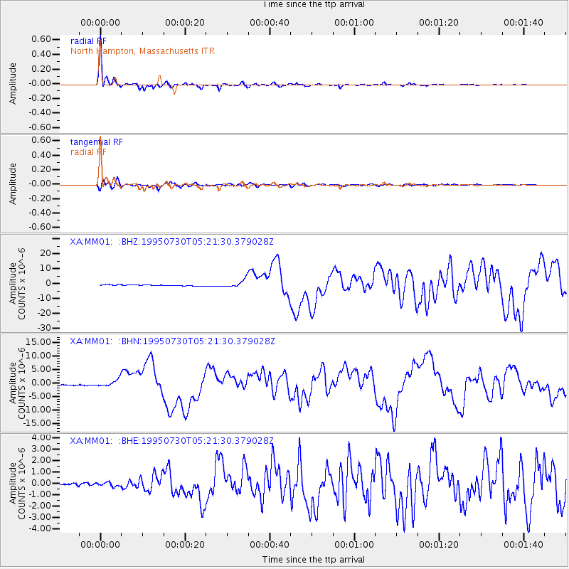
Earthquake location: Near Coast Of Northern Chile
Earthquake latitude/longitude: -23.4/-70.3
Earthquake time(UTC): 1995/07/30 (211) 05:11:23 GMT
Earthquake Depth: 47 km
Earthquake Magnitude: 6.6 MB, 7.3 MS, 7.2 UNKNOWN, 8.1 MW
Earthquake Catalog/Contributor: WHDF/NEIC
Network: XA Missouri to Massachusetts Transect
Station: MM01 North Hampton, Massachusetts
Lat/Lon: 42.32 N/72.71 W
Elevation: 122 m
Distance: 65.4 deg
Az: 358.043 deg
Baz: 177.574 deg
Ray Param: 0.058208853
Estimated Moho Depth: 34.75 km
Estimated Crust Vp/Vs: 1.61
Assumed Crust Vp: 6.419 km/s
Estimated Crust Vs: 4.0 km/s
Estimated Crust Poisson's Ratio: 0.18
Radial Match: 98.742775 %
Radial Bump: 267
Transverse Match: 94.93017 %
Transverse Bump: 400
SOD ConfigId: 6273
Insert Time: 2010-02-26 17:42:25.243 +0000
GWidth: 2.5
Max Bumps: 400
Tol: 0.001

Signal To Noise

ChannelStoNSTALTA
XA:MM01: :BHN:19950730T05:21:30.379028Z5.8371641.2854175E-62.2021268E-7
XA:MM01: :BHE:19950730T05:21:30.379028Z1.88607051.8162847E-79.6299935E-8
XA:MM01: :BHZ:19950730T05:21:30.379028Z8.3525592.8322906E-63.3909257E-7
Arrivals
Ps3.4 SECOND
PpPs13 SECOND
PsPs/PpSs17 SECOND