You are here: Home > Network List > G - GEOSCOPE Stations List
> Station FOMA Nahampoana reservation, Fort Dauphin, Madagascar > Earthquake Result Viewer
FOMA Nahampoana reservation, Fort Dauphin, Madagascar - Earthquake Result Viewer
| Earthquake location: |
Eastern New Guinea Reg., P.N.G. |
| Earthquake latitude/longitude: |
-6.2/146.5 |
| Earthquake time(UTC): |
2022/09/10 (253) 23:46:55 GMT |
| Earthquake Depth: |
61 km |
| Earthquake Magnitude: |
7.6 mww |
| Earthquake Catalog/Contributor: |
NEIC PDE/us |
|
| Network: |
G GEOSCOPE |
| Station: |
FOMA Nahampoana reservation, Fort Dauphin, Madagascar |
| Lat/Lon: |
24.98 S/46.98 E |
| Elevation: |
26 m |
|
| Distance: |
95.9 deg |
| Az: |
244.156 deg |
| Baz: |
99.642 deg |
| Ray Param: |
0.040615767 |
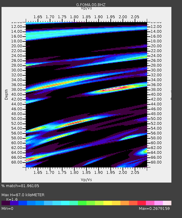
| Estimated Moho Depth: |
67.0 km |
| Estimated Crust Vp/Vs: |
1.60 |
| Assumed Crust Vp: |
6.183 km/s |
| Estimated Crust Vs: |
3.864 km/s |
| Estimated Crust Poisson's Ratio: |
0.18 |
|
| Radial Match: |
81.96185 % |
| Radial Bump: |
362 |
| Transverse Match: |
74.81435 % |
| Transverse Bump: |
400 |
| SOD ConfigId: |
28764291 |
| Insert Time: |
2022-09-25 00:02:26.025 +0000 |
| GWidth: |
2.5 |
| Max Bumps: |
400 |
| Tol: |
0.001 |
|

Signal To Noise
| Channel | StoN | STA | LTA |
| G:FOMA:00:BHZ:20220910T23:59:43.949979Z | 3.6078105 | 2.812598E-6 | 7.7958583E-7 |
| G:FOMA:00:BHN:20220910T23:59:43.949979Z | 1.3542554 | 5.2811697E-7 | 3.8996848E-7 |
| G:FOMA:00:BHE:20220910T23:59:43.949979Z | 1.9538579 | 1.0315133E-6 | 5.279367E-7 |
| Arrivals |
| Ps | 6.6 SECOND |
| PpPs | 28 SECOND |
| PsPs/PpSs | 34 SECOND |


