You are here: Home > Network List > TA - USArray Transportable Network (new EarthScope stations) Stations List
> Station R23A Moffat, CO, USA > Earthquake Result Viewer
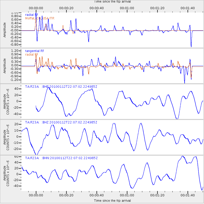
R23A Moffat, CO, USA - Earthquake Result Viewer
*The percent match for this event was below the threshold and hence no stack was calculated.
| Earthquake location: |
Haiti Region |
| Earthquake latitude/longitude: |
18.4/-72.8 |
| Earthquake time(UTC): |
2010/01/12 (012) 22:00:41 GMT |
| Earthquake Depth: |
10 km |
| Earthquake Magnitude: |
6.0 MB |
| Earthquake Catalog/Contributor: |
WHDF/NEIC |
|
| Network: |
TA USArray Transportable Network (new EarthScope stations) |
| Station: |
R23A Moffat, CO, USA |
| Lat/Lon: |
38.19 N/105.83 W |
| Elevation: |
2547 m |
|
| Distance: |
34.9 deg |
| Az: |
311.309 deg |
| Baz: |
115.147 deg |
| Ray Param: |
$rayparam |
*The percent match for this event was below the threshold and hence was not used in the summary stack. |
|
| Radial Match: |
73.21859 % |
| Radial Bump: |
362 |
| Transverse Match: |
57.360104 % |
| Transverse Bump: |
400 |
| SOD ConfigId: |
1 |
| Insert Time: |
2010-03-17 21:19:29.924 +0000 |
| GWidth: |
2.5 |
| Max Bumps: |
400 |
| Tol: |
0.001 |
|
Signal To Noise
| Channel | StoN | STA | LTA |
| TA:R23A: :BHZ:20100112T22:07:02.224985Z | 2.4310381 | 2.528256E-5 | 1.0399903E-5 |
| TA:R23A: :BHN:20100112T22:07:02.224985Z | 0.645925 | 8.0540785E-6 | 1.2469062E-5 |
| TA:R23A: :BHE:20100112T22:07:02.224985Z | 1.1625952 | 3.417759E-5 | 2.9397668E-5 |
| Arrivals |
| Ps | |
| PpPs | |
| PsPs/PpSs | |


