You are here: Home > Network List > IU - Global Seismograph Network (GSN - IRIS/USGS) Stations List
> Station JOHN Johnston Island, USA > Earthquake Result Viewer
JOHN Johnston Island, USA - Earthquake Result Viewer

| Earthquake location: |
Eastern New Guinea Reg., P.N.G. |
| Earthquake latitude/longitude: |
-6.2/146.5 |
| Earthquake time(UTC): |
2022/09/10 (253) 23:46:55 GMT |
| Earthquake Depth: |
61 km |
| Earthquake Magnitude: |
7.6 mww |
| Earthquake Catalog/Contributor: |
NEIC PDE/us |
|
| Network: |
IU Global Seismograph Network (GSN - IRIS/USGS) |
| Station: |
JOHN Johnston Island, USA |
| Lat/Lon: |
16.73 N/169.53 W |
| Elevation: |
2.0 m |
|
| Distance: |
49.1 deg |
| Az: |
61.679 deg |
| Baz: |
245.976 deg |
| Ray Param: |
0.06874694 |
| Estimated Moho Depth: |
61.75 km |
| Estimated Crust Vp/Vs: |
2.08 |
| Assumed Crust Vp: |
4.24 km/s |
| Estimated Crust Vs: |
2.043 km/s |
| Estimated Crust Poisson's Ratio: |
0.35 |
|
| Radial Match: |
85.78695 % |
| Radial Bump: |
340 |
| Transverse Match: |
79.57761 % |
| Transverse Bump: |
400 |
| SOD ConfigId: |
28764291 |
| Insert Time: |
2022-09-25 00:05:37.740 +0000 |
| GWidth: |
2.5 |
| Max Bumps: |
400 |
| Tol: |
0.001 |
|
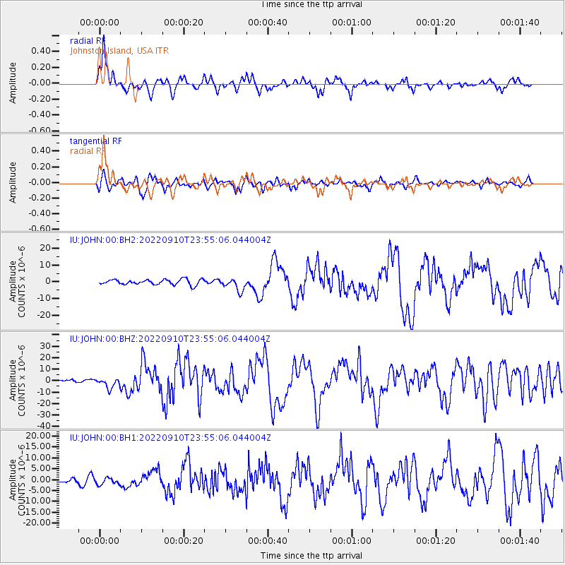
Signal To Noise
| Channel | StoN | STA | LTA |
| IU:JOHN:00:BHZ:20220910T23:55:06.044004Z | 4.4358296 | 4.514398E-6 | 1.0177123E-6 |
| IU:JOHN:00:BH1:20220910T23:55:06.044004Z | 1.0510609 | 1.577103E-6 | 1.5004867E-6 |
| IU:JOHN:00:BH2:20220910T23:55:06.044004Z | 2.504612 | 3.893517E-6 | 1.5545388E-6 |
| Arrivals |
| Ps | 16 SECOND |
| PpPs | 44 SECOND |
| PsPs/PpSs | 60 SECOND |


