You are here: Home > Network List > TA - USArray Transportable Network (new EarthScope stations) Stations List
> Station T26A Comanche National Grassland Park, Kim, CO, USA > Earthquake Result Viewer
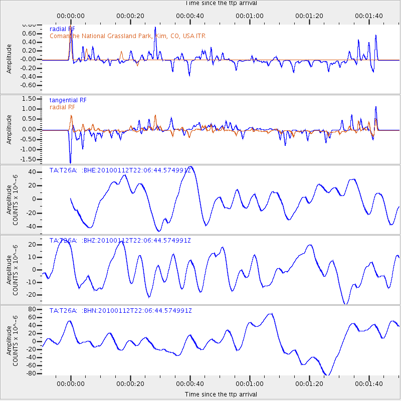
T26A Comanche National Grassland Park, Kim, CO, USA - Earthquake Result Viewer
*The percent match for this event was below the threshold and hence no stack was calculated.
| Earthquake location: |
Haiti Region |
| Earthquake latitude/longitude: |
18.4/-72.8 |
| Earthquake time(UTC): |
2010/01/12 (012) 22:00:41 GMT |
| Earthquake Depth: |
10 km |
| Earthquake Magnitude: |
6.0 MB |
| Earthquake Catalog/Contributor: |
WHDF/NEIC |
|
| Network: |
TA USArray Transportable Network (new EarthScope stations) |
| Station: |
T26A Comanche National Grassland Park, Kim, CO, USA |
| Lat/Lon: |
37.17 N/103.59 W |
| Elevation: |
1830 m |
|
| Distance: |
32.9 deg |
| Az: |
311.049 deg |
| Baz: |
116.291 deg |
| Ray Param: |
$rayparam |
*The percent match for this event was below the threshold and hence was not used in the summary stack. |
|
| Radial Match: |
61.856667 % |
| Radial Bump: |
372 |
| Transverse Match: |
64.60929 % |
| Transverse Bump: |
335 |
| SOD ConfigId: |
1 |
| Insert Time: |
2010-03-17 21:19:48.249 +0000 |
| GWidth: |
2.5 |
| Max Bumps: |
400 |
| Tol: |
0.001 |
|
Signal To Noise
| Channel | StoN | STA | LTA |
| TA:T26A: :BHZ:20100112T22:06:44.574991Z | 0.9119128 | 1.3517853E-5 | 1.4823625E-5 |
| TA:T26A: :BHN:20100112T22:06:44.574991Z | 1.8173063 | 3.0275813E-5 | 1.665972E-5 |
| TA:T26A: :BHE:20100112T22:06:44.574991Z | 1.4898945 | 3.5527097E-5 | 2.3845378E-5 |
| Arrivals |
| Ps | |
| PpPs | |
| PsPs/PpSs | |


