You are here: Home > Network List > MM - Myanmar National Seismic Network Stations List
> Station TGI Taung Gyi, Myanmar > Earthquake Result Viewer
TGI Taung Gyi, Myanmar - Earthquake Result Viewer
| Earthquake location: |
Eastern New Guinea Reg., P.N.G. |
| Earthquake latitude/longitude: |
-6.2/146.5 |
| Earthquake time(UTC): |
2022/09/10 (253) 23:46:55 GMT |
| Earthquake Depth: |
61 km |
| Earthquake Magnitude: |
7.6 mww |
| Earthquake Catalog/Contributor: |
NEIC PDE/us |
|
| Network: |
MM Myanmar National Seismic Network |
| Station: |
TGI Taung Gyi, Myanmar |
| Lat/Lon: |
20.77 N/97.03 E |
| Elevation: |
1458 m |
|
| Distance: |
55.5 deg |
| Az: |
300.334 deg |
| Baz: |
113.518 deg |
| Ray Param: |
0.064626485 |
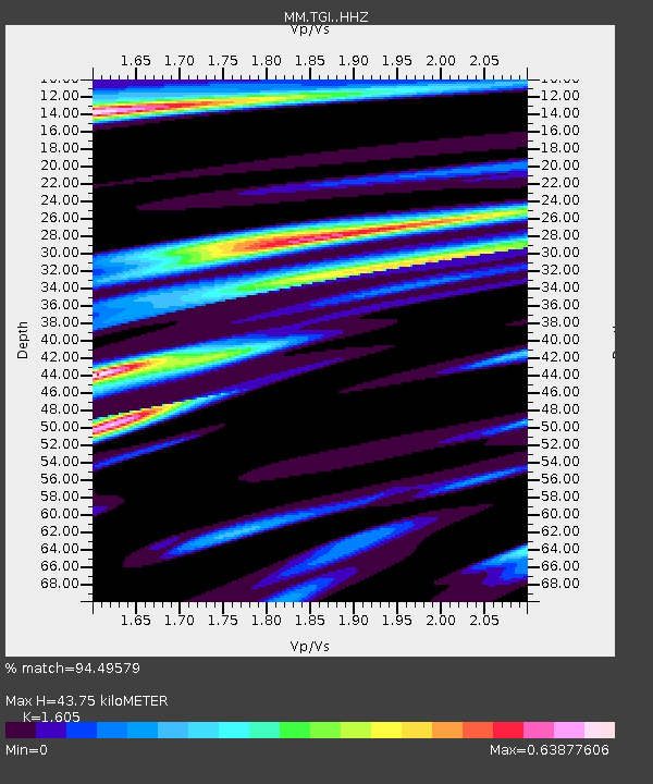
| Estimated Moho Depth: |
43.75 km |
| Estimated Crust Vp/Vs: |
1.61 |
| Assumed Crust Vp: |
6.316 km/s |
| Estimated Crust Vs: |
3.935 km/s |
| Estimated Crust Poisson's Ratio: |
0.18 |
|
| Radial Match: |
94.49579 % |
| Radial Bump: |
246 |
| Transverse Match: |
82.24858 % |
| Transverse Bump: |
400 |
| SOD ConfigId: |
28764291 |
| Insert Time: |
2022-09-25 00:07:27.187 +0000 |
| GWidth: |
2.5 |
| Max Bumps: |
400 |
| Tol: |
0.001 |
|

Signal To Noise
| Channel | StoN | STA | LTA |
| MM:TGI: :HHZ:20220910T23:55:52.870023Z | 6.0830774 | 3.813017E-6 | 6.2682363E-7 |
| MM:TGI: :HHN:20220910T23:55:52.870023Z | 1.6848941 | 1.142099E-6 | 6.778462E-7 |
| MM:TGI: :HHE:20220910T23:55:52.870023Z | 5.135789 | 3.414685E-6 | 6.648803E-7 |
| Arrivals |
| Ps | 4.4 SECOND |
| PpPs | 17 SECOND |
| PsPs/PpSs | 22 SECOND |


