You are here: Home > Network List > PQ - Public Safety Geoscience Program Canadian Research Network (PSGP) Stations List
> Station ALBHB Albert Head, Victoria, BC, Canada > Earthquake Result Viewer
ALBHB Albert Head, Victoria, BC, Canada - Earthquake Result Viewer
| Earthquake location: |
Eastern New Guinea Reg., P.N.G. |
| Earthquake latitude/longitude: |
-6.2/146.5 |
| Earthquake time(UTC): |
2022/09/10 (253) 23:46:55 GMT |
| Earthquake Depth: |
61 km |
| Earthquake Magnitude: |
7.6 mww |
| Earthquake Catalog/Contributor: |
NEIC PDE/us |
|
| Network: |
PQ Public Safety Geoscience Program Canadian Research Network (PSGP) |
| Station: |
ALBHB Albert Head, Victoria, BC, Canada |
| Lat/Lon: |
48.39 N/123.49 W |
| Elevation: |
40 m |
|
| Distance: |
94.6 deg |
| Az: |
41.969 deg |
| Baz: |
265.901 deg |
| Ray Param: |
0.040962722 |
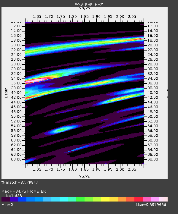
| Estimated Moho Depth: |
34.75 km |
| Estimated Crust Vp/Vs: |
1.63 |
| Assumed Crust Vp: |
6.566 km/s |
| Estimated Crust Vs: |
4.016 km/s |
| Estimated Crust Poisson's Ratio: |
0.20 |
|
| Radial Match: |
87.79947 % |
| Radial Bump: |
400 |
| Transverse Match: |
78.7506 % |
| Transverse Bump: |
400 |
| SOD ConfigId: |
28764291 |
| Insert Time: |
2022-09-25 00:09:39.001 +0000 |
| GWidth: |
2.5 |
| Max Bumps: |
400 |
| Tol: |
0.001 |
|

Signal To Noise
| Channel | StoN | STA | LTA |
| PQ:ALBHB: :HHZ:20220910T23:59:37.990018Z | 10.679779 | 2.50164E-6 | 2.342408E-7 |
| PQ:ALBHB: :HHN:20220910T23:59:37.990018Z | 0.82922596 | 2.3477428E-7 | 2.8312462E-7 |
| PQ:ALBHB: :HHE:20220910T23:59:37.990018Z | 4.7590766 | 1.0055338E-6 | 2.1128758E-7 |
| Arrivals |
| Ps | 3.4 SECOND |
| PpPs | 14 SECOND |
| PsPs/PpSs | 17 SECOND |


