You are here: Home > Network List > UW - Pacific Northwest Regional Seismic Network Stations List
> Station PASS Maple Falls, WA, USA > Earthquake Result Viewer
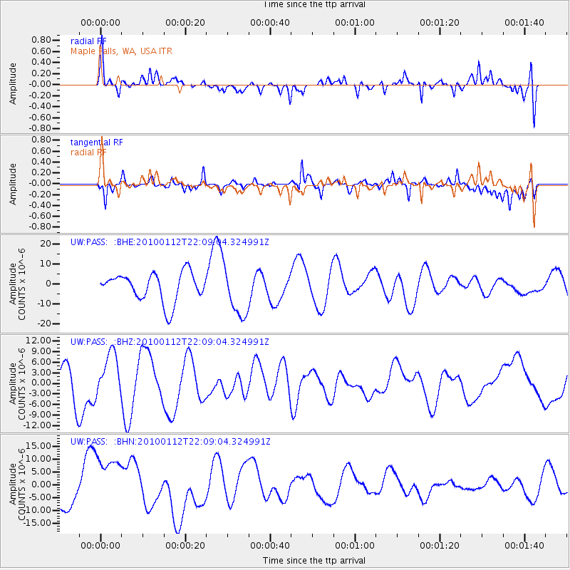
PASS Maple Falls, WA, USA - Earthquake Result Viewer
*The percent match for this event was below the threshold and hence no stack was calculated.
| Earthquake location: |
Haiti Region |
| Earthquake latitude/longitude: |
18.4/-72.8 |
| Earthquake time(UTC): |
2010/01/12 (012) 22:00:41 GMT |
| Earthquake Depth: |
10 km |
| Earthquake Magnitude: |
6.0 MB |
| Earthquake Catalog/Contributor: |
WHDF/NEIC |
|
| Network: |
UW Pacific Northwest Regional Seismic Network |
| Station: |
PASS Maple Falls, WA, USA |
| Lat/Lon: |
49.00 N/122.09 W |
| Elevation: |
174 m |
|
| Distance: |
49.9 deg |
| Az: |
319.271 deg |
| Baz: |
109.82 deg |
| Ray Param: |
$rayparam |
*The percent match for this event was below the threshold and hence was not used in the summary stack. |
|
| Radial Match: |
64.90983 % |
| Radial Bump: |
400 |
| Transverse Match: |
56.94324 % |
| Transverse Bump: |
400 |
| SOD ConfigId: |
1 |
| Insert Time: |
2010-03-17 21:23:17.328 +0000 |
| GWidth: |
2.5 |
| Max Bumps: |
400 |
| Tol: |
0.001 |
|
Signal To Noise
| Channel | StoN | STA | LTA |
| UW:PASS: :BHZ:20100112T22:09:04.324991Z | 1.5644037 | 6.3437546E-6 | 4.055062E-6 |
| UW:PASS: :BHN:20100112T22:09:04.324991Z | 2.508775 | 1.1941737E-5 | 4.7599874E-6 |
| UW:PASS: :BHE:20100112T22:09:04.324991Z | 1.7135961 | 1.2347725E-5 | 7.2057383E-6 |
| Arrivals |
| Ps | |
| PpPs | |
| PsPs/PpSs | |


