You are here: Home > Network List > UW - Pacific Northwest Regional Seismic Network Stations List
> Station RNWY Roche Harbor Airport, San Juan Island, WA, USA > Earthquake Result Viewer
RNWY Roche Harbor Airport, San Juan Island, WA, USA - Earthquake Result Viewer
| Earthquake location: |
Eastern New Guinea Reg., P.N.G. |
| Earthquake latitude/longitude: |
-6.2/146.5 |
| Earthquake time(UTC): |
2022/09/10 (253) 23:46:55 GMT |
| Earthquake Depth: |
61 km |
| Earthquake Magnitude: |
7.6 mww |
| Earthquake Catalog/Contributor: |
NEIC PDE/us |
|
| Network: |
UW Pacific Northwest Regional Seismic Network |
| Station: |
RNWY Roche Harbor Airport, San Juan Island, WA, USA |
| Lat/Lon: |
48.61 N/123.13 W |
| Elevation: |
58 m |
|
| Distance: |
94.9 deg |
| Az: |
41.763 deg |
| Baz: |
266.188 deg |
| Ray Param: |
0.04089889 |
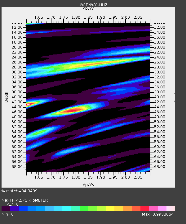
| Estimated Moho Depth: |
42.75 km |
| Estimated Crust Vp/Vs: |
1.60 |
| Assumed Crust Vp: |
6.566 km/s |
| Estimated Crust Vs: |
4.104 km/s |
| Estimated Crust Poisson's Ratio: |
0.18 |
|
| Radial Match: |
84.3489 % |
| Radial Bump: |
400 |
| Transverse Match: |
75.607994 % |
| Transverse Bump: |
400 |
| SOD ConfigId: |
28764291 |
| Insert Time: |
2022-09-25 00:15:31.789 +0000 |
| GWidth: |
2.5 |
| Max Bumps: |
400 |
| Tol: |
0.001 |
|

Signal To Noise
| Channel | StoN | STA | LTA |
| UW:RNWY: :HHZ:20220910T23:59:39.149991Z | 8.354294 | 2.7793415E-6 | 3.3268415E-7 |
| UW:RNWY: :HHN:20220910T23:59:39.149991Z | 1.346879 | 5.6699935E-7 | 4.2097275E-7 |
| UW:RNWY: :HHE:20220910T23:59:39.149991Z | 3.4563115 | 1.210956E-6 | 3.503608E-7 |
| Arrivals |
| Ps | 4.0 SECOND |
| PpPs | 17 SECOND |
| PsPs/PpSs | 21 SECOND |


