You are here: Home > Network List > XA95 - Missouri to Massachusetts Transect Stations List
> Station MM01 North Hampton, Massachusetts > Earthquake Result Viewer
MM01 North Hampton, Massachusetts - Earthquake Result Viewer
| Earthquake location: |
Greece |
| Earthquake latitude/longitude: |
40.1/21.7 |
| Earthquake time(UTC): |
1995/05/13 (133) 08:47:12 GMT |
| Earthquake Depth: |
13 km |
| Earthquake Magnitude: |
6.2 MB, 6.5 MS, 6.6 UNKNOWN, 6.5 MD |
| Earthquake Catalog/Contributor: |
WHDF/NEIC |
|
| Network: |
XA Missouri to Massachusetts Transect |
| Station: |
MM01 North Hampton, Massachusetts |
| Lat/Lon: |
42.32 N/72.71 W |
| Elevation: |
122 m |
|
| Distance: |
67.2 deg |
| Az: |
306.674 deg |
| Baz: |
55.991 deg |
| Ray Param: |
0.05709156 |
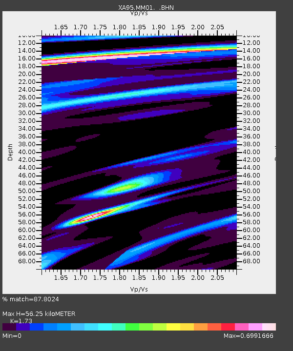
| Estimated Moho Depth: |
56.25 km |
| Estimated Crust Vp/Vs: |
1.73 |
| Assumed Crust Vp: |
6.419 km/s |
| Estimated Crust Vs: |
3.711 km/s |
| Estimated Crust Poisson's Ratio: |
0.25 |
|
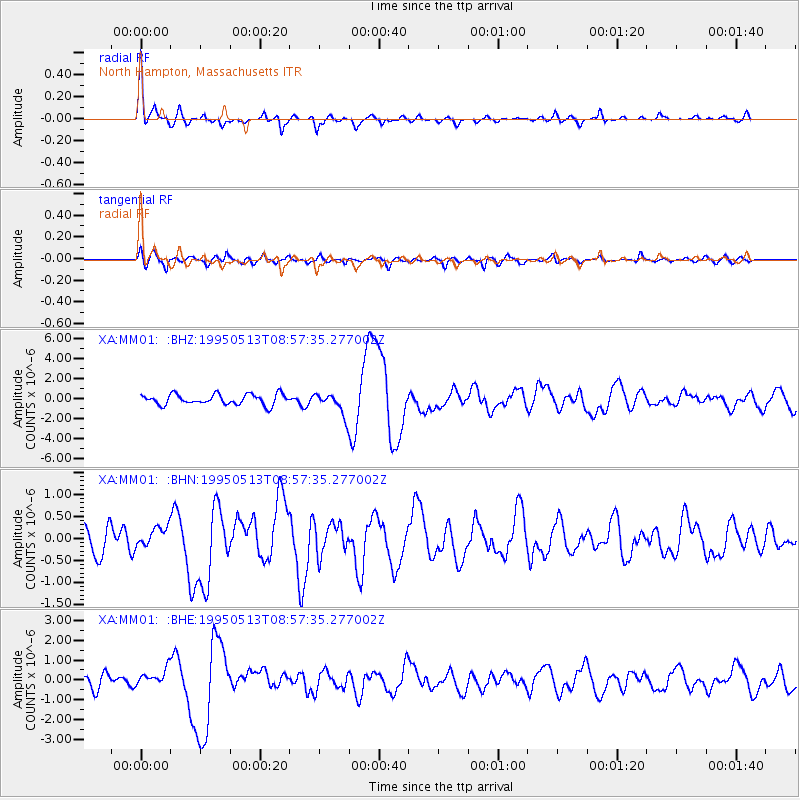
| Radial Match: |
87.8024 % |
| Radial Bump: |
388 |
| Transverse Match: |
75.9322 % |
| Transverse Bump: |
400 |
| SOD ConfigId: |
6273 |
| Insert Time: |
2010-02-26 17:42:35.827 +0000 |
| GWidth: |
2.5 |
| Max Bumps: |
400 |
| Tol: |
0.001 |
|
Signal To Noise
| Channel | StoN | STA | LTA |
| XA:MM01: :BHN:19950513T08:57:35.277002Z | 0.6425774 | 2.2882801E-7 | 3.5610967E-7 |
| XA:MM01: :BHE:19950513T08:57:35.277002Z | 1.354765 | 4.2091773E-7 | 3.1069428E-7 |
| XA:MM01: :BHZ:19950513T08:57:35.277002Z | 2.1433415 | 1.1182035E-6 | 5.217104E-7 |
| Arrivals |
| Ps | 6.7 SECOND |
| PpPs | 23 SECOND |
| PsPs/PpSs | 30 SECOND |


