You are here: Home > Network List > AV - Alaska Volcano Observatory Stations List
> Station MAPS Pakushin Southeast, Makushin Volcano, Alaska > Earthquake Result Viewer
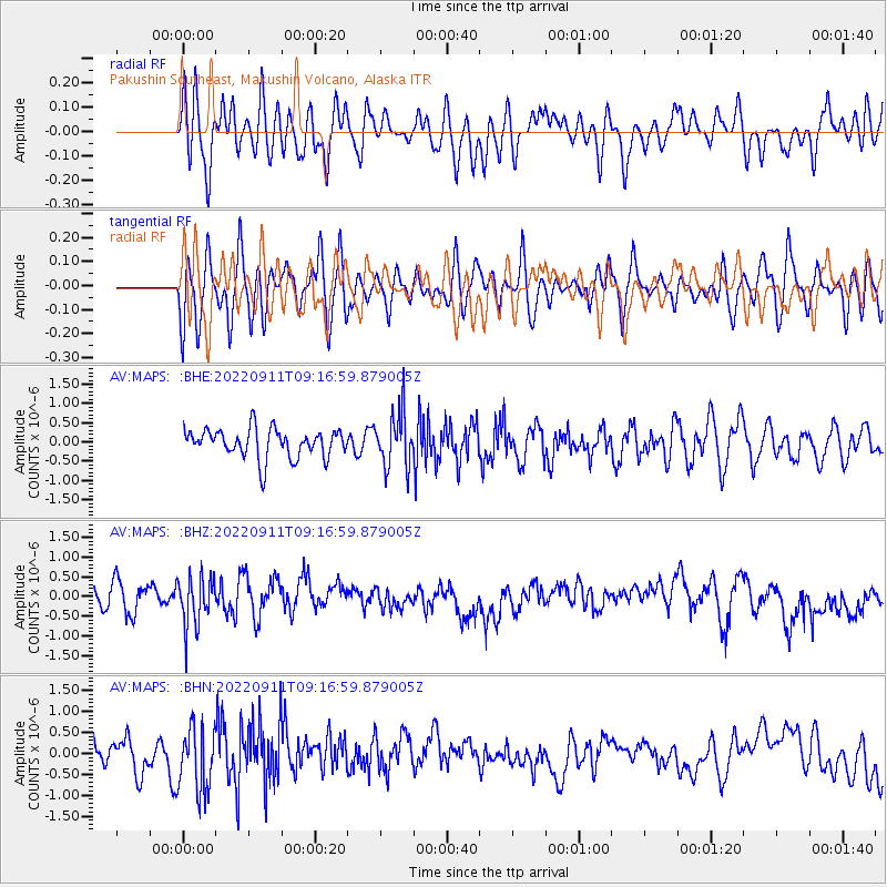
MAPS Pakushin Southeast, Makushin Volcano, Alaska - Earthquake Result Viewer
*The percent match for this event was below the threshold and hence no stack was calculated.
| Earthquake location: |
Fiji Islands Region |
| Earthquake latitude/longitude: |
-21.0/-178.9 |
| Earthquake time(UTC): |
2022/09/11 (254) 09:06:51 GMT |
| Earthquake Depth: |
630 km |
| Earthquake Magnitude: |
5.5 mb |
| Earthquake Catalog/Contributor: |
NEIC PDE/us |
|
| Network: |
AV Alaska Volcano Observatory |
| Station: |
MAPS Pakushin Southeast, Makushin Volcano, Alaska |
| Lat/Lon: |
53.81 N/166.94 W |
| Elevation: |
333 m |
|
| Distance: |
75.2 deg |
| Az: |
7.33 deg |
| Baz: |
191.598 deg |
| Ray Param: |
$rayparam |
*The percent match for this event was below the threshold and hence was not used in the summary stack. |
|
| Radial Match: |
42.624367 % |
| Radial Bump: |
400 |
| Transverse Match: |
45.88354 % |
| Transverse Bump: |
400 |
| SOD ConfigId: |
28764291 |
| Insert Time: |
2022-09-25 09:17:37.344 +0000 |
| GWidth: |
2.5 |
| Max Bumps: |
400 |
| Tol: |
0.001 |
|
Signal To Noise
| Channel | StoN | STA | LTA |
| AV:MAPS: :BHZ:20220911T09:16:59.879005Z | 1.6950089 | 6.389835E-7 | 3.7697944E-7 |
| AV:MAPS: :BHN:20220911T09:16:59.879005Z | 2.0028124 | 7.6729253E-7 | 3.8310753E-7 |
| AV:MAPS: :BHE:20220911T09:16:59.879005Z | 1.8173811 | 6.8409565E-7 | 3.7641837E-7 |
| Arrivals |
| Ps | |
| PpPs | |
| PsPs/PpSs | |


