You are here: Home > Network List > XA95 - Missouri to Massachusetts Transect Stations List
> Station MM01 North Hampton, Massachusetts > Earthquake Result Viewer
MM01 North Hampton, Massachusetts - Earthquake Result Viewer
| Earthquake location: |
Turkey |
| Earthquake latitude/longitude: |
38.1/30.2 |
| Earthquake time(UTC): |
1995/10/01 (274) 15:57:16 GMT |
| Earthquake Depth: |
33 km |
| Earthquake Magnitude: |
5.7 MB, 6.1 MS, 6.3 UNKNOWN, 6.0 MW |
| Earthquake Catalog/Contributor: |
WHDF/NEIC |
|
| Network: |
XA Missouri to Massachusetts Transect |
| Station: |
MM01 North Hampton, Massachusetts |
| Lat/Lon: |
42.32 N/72.71 W |
| Elevation: |
122 m |
|
| Distance: |
73.6 deg |
| Az: |
311.106 deg |
| Baz: |
53.276 deg |
| Ray Param: |
0.052820683 |
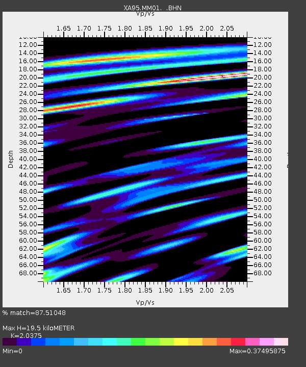
| Estimated Moho Depth: |
19.5 km |
| Estimated Crust Vp/Vs: |
2.04 |
| Assumed Crust Vp: |
6.419 km/s |
| Estimated Crust Vs: |
3.151 km/s |
| Estimated Crust Poisson's Ratio: |
0.34 |
|
| Radial Match: |
87.51048 % |
| Radial Bump: |
328 |
| Transverse Match: |
69.62951 % |
| Transverse Bump: |
383 |
| SOD ConfigId: |
6273 |
| Insert Time: |
2010-02-26 17:42:43.230 +0000 |
| GWidth: |
2.5 |
| Max Bumps: |
400 |
| Tol: |
0.001 |
|

Signal To Noise
| Channel | StoN | STA | LTA |
| XA:MM01: :BHN:19951001T16:08:15.210999Z | 2.3391414 | 4.9392133E-7 | 2.1115497E-7 |
| XA:MM01: :BHE:19951001T16:08:15.210999Z | 2.4887 | 8.1201523E-7 | 3.2628088E-7 |
| XA:MM01: :BHZ:19951001T16:08:15.210999Z | 2.6446335 | 1.6719176E-6 | 6.3219255E-7 |
| Arrivals |
| Ps | 3.2 SECOND |
| PpPs | 9.0 SECOND |
| PsPs/PpSs | 12 SECOND |


