You are here: Home > Network List > GT - Global Telemetered Seismograph Network (USAF/USGS) Stations List
> Station PLCA Paso Flores, Argentina > Earthquake Result Viewer
PLCA Paso Flores, Argentina - Earthquake Result Viewer
| Earthquake location: |
Haiti Region |
| Earthquake latitude/longitude: |
18.5/-72.5 |
| Earthquake time(UTC): |
2010/01/12 (012) 22:12:04 GMT |
| Earthquake Depth: |
10 km |
| Earthquake Magnitude: |
5.7 MB |
| Earthquake Catalog/Contributor: |
WHDF/NEIC |
|
| Network: |
GT Global Telemetered Seismograph Network (USAF/USGS) |
| Station: |
PLCA Paso Flores, Argentina |
| Lat/Lon: |
40.73 S/70.55 W |
| Elevation: |
1050 m |
|
| Distance: |
58.9 deg |
| Az: |
178.259 deg |
| Baz: |
357.825 deg |
| Ray Param: |
0.06253829 |
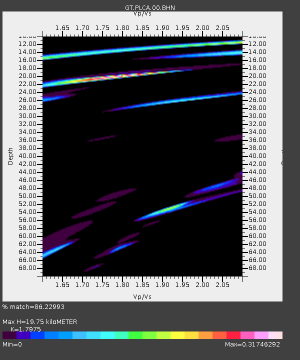
| Estimated Moho Depth: |
19.75 km |
| Estimated Crust Vp/Vs: |
1.80 |
| Assumed Crust Vp: |
6.597 km/s |
| Estimated Crust Vs: |
3.67 km/s |
| Estimated Crust Poisson's Ratio: |
0.28 |
|
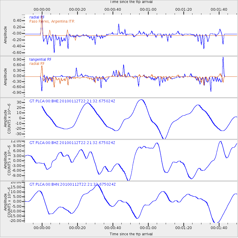
| Radial Match: |
86.22993 % |
| Radial Bump: |
400 |
| Transverse Match: |
58.019703 % |
| Transverse Bump: |
323 |
| SOD ConfigId: |
1 |
| Insert Time: |
2010-03-17 21:31:02.421 +0000 |
| GWidth: |
2.5 |
| Max Bumps: |
400 |
| Tol: |
0.001 |
|
Signal To Noise
| Channel | StoN | STA | LTA |
| GT:PLCA:00:BHZ:20100112T22:21:32.675024Z | 0.63005584 | 2.4697533E-6 | 3.919896E-6 |
| GT:PLCA:00:BHN:20100112T22:21:32.675024Z | 2.63863 | 8.582051E-6 | 3.252465E-6 |
| GT:PLCA:00:BHE:20100112T22:21:32.675024Z | 0.7977461 | 1.2166358E-5 | 1.5250915E-5 |
| Arrivals |
| Ps | 2.5 SECOND |
| PpPs | 8.0 SECOND |
| PsPs/PpSs | 10 SECOND |


