You are here: Home > Network List > XA95 - Missouri to Massachusetts Transect Stations List
> Station MM01 North Hampton, Massachusetts > Earthquake Result Viewer
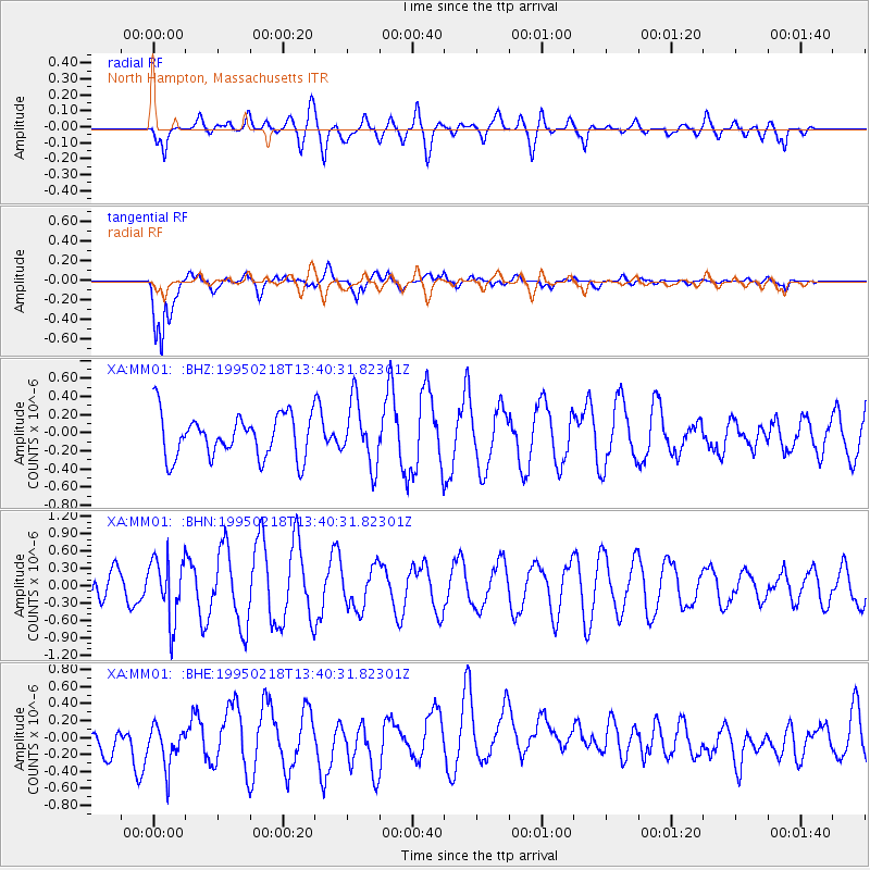
MM01 North Hampton, Massachusetts - Earthquake Result Viewer
*The percent match for this event was below the threshold and hence no stack was calculated.
| Earthquake location: |
Sea Of Okhotsk |
| Earthquake latitude/longitude: |
46.7/145.9 |
| Earthquake time(UTC): |
1995/02/18 (049) 13:29:06 GMT |
| Earthquake Depth: |
355 km |
| Earthquake Magnitude: |
5.6 MB, 5.7 UNKNOWN, 5.5 MW |
| Earthquake Catalog/Contributor: |
WHDF/NEIC |
|
| Network: |
XA Missouri to Massachusetts Transect |
| Station: |
MM01 North Hampton, Massachusetts |
| Lat/Lon: |
42.32 N/72.71 W |
| Elevation: |
122 m |
|
| Distance: |
85.0 deg |
| Az: |
27.681 deg |
| Baz: |
334.447 deg |
| Ray Param: |
$rayparam |
*The percent match for this event was below the threshold and hence was not used in the summary stack. |
|
| Radial Match: |
38.29556 % |
| Radial Bump: |
400 |
| Transverse Match: |
79.50011 % |
| Transverse Bump: |
400 |
| SOD ConfigId: |
4480 |
| Insert Time: |
2010-02-26 17:42:49.161 +0000 |
| GWidth: |
2.5 |
| Max Bumps: |
400 |
| Tol: |
0.001 |
|
Signal To Noise
| Channel | StoN | STA | LTA |
| XA:MM01: :BHN:19950218T13:40:31.82301Z | 2.0599904 | 5.237936E-7 | 2.542699E-7 |
| XA:MM01: :BHE:19950218T13:40:31.82301Z | 1.1943586 | 2.8366807E-7 | 2.3750661E-7 |
| XA:MM01: :BHZ:19950218T13:40:31.82301Z | 1.4634621 | 3.4796662E-7 | 2.3776948E-7 |
| Arrivals |
| Ps | |
| PpPs | |
| PsPs/PpSs | |


