You are here: Home > Network List > TA - USArray Transportable Network (new EarthScope stations) Stations List
> Station U23A El Rito, NM, USA > Earthquake Result Viewer
U23A El Rito, NM, USA - Earthquake Result Viewer
| Earthquake location: |
Haiti Region |
| Earthquake latitude/longitude: |
18.5/-72.5 |
| Earthquake time(UTC): |
2010/01/12 (012) 22:12:04 GMT |
| Earthquake Depth: |
10 km |
| Earthquake Magnitude: |
5.7 MB |
| Earthquake Catalog/Contributor: |
WHDF/NEIC |
|
| Network: |
TA USArray Transportable Network (new EarthScope stations) |
| Station: |
U23A El Rito, NM, USA |
| Lat/Lon: |
36.33 N/106.19 W |
| Elevation: |
2093 m |
|
| Distance: |
34.6 deg |
| Az: |
307.89 deg |
| Baz: |
111.925 deg |
| Ray Param: |
0.07767321 |
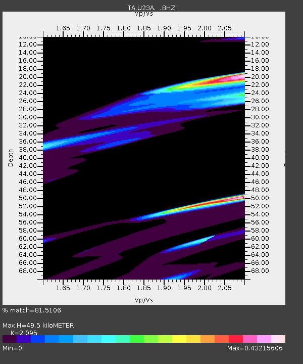
| Estimated Moho Depth: |
49.5 km |
| Estimated Crust Vp/Vs: |
2.10 |
| Assumed Crust Vp: |
6.159 km/s |
| Estimated Crust Vs: |
2.94 km/s |
| Estimated Crust Poisson's Ratio: |
0.35 |
|
| Radial Match: |
81.5106 % |
| Radial Bump: |
400 |
| Transverse Match: |
56.02602 % |
| Transverse Bump: |
380 |
| SOD ConfigId: |
1 |
| Insert Time: |
2010-03-17 21:35:11.060 +0000 |
| GWidth: |
2.5 |
| Max Bumps: |
400 |
| Tol: |
0.001 |
|

Signal To Noise
| Channel | StoN | STA | LTA |
| TA:U23A: :BHZ:20100112T22:18:22.650Z | 1.40517 | 6.7726294E-5 | 4.8197937E-5 |
| TA:U23A: :BHN:20100112T22:18:22.650Z | 3.5168252 | 1.0295916E-4 | 2.9276165E-5 |
| TA:U23A: :BHE:20100112T22:18:22.650Z | 1.1209135 | 5.923551E-5 | 5.284575E-5 |
| Arrivals |
| Ps | 9.3 SECOND |
| PpPs | 23 SECOND |
| PsPs/PpSs | 33 SECOND |


