You are here: Home > Network List > TA - USArray Transportable Network (new EarthScope stations) Stations List
> Station P27A Ficken Ranch, Kirk, CO, USA > Earthquake Result Viewer
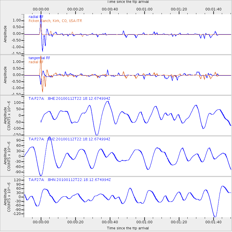
P27A Ficken Ranch, Kirk, CO, USA - Earthquake Result Viewer
*The percent match for this event was below the threshold and hence no stack was calculated.
| Earthquake location: |
Haiti Region |
| Earthquake latitude/longitude: |
18.5/-72.5 |
| Earthquake time(UTC): |
2010/01/12 (012) 22:12:04 GMT |
| Earthquake Depth: |
10 km |
| Earthquake Magnitude: |
5.7 MB |
| Earthquake Catalog/Contributor: |
WHDF/NEIC |
|
| Network: |
TA USArray Transportable Network (new EarthScope stations) |
| Station: |
P27A Ficken Ranch, Kirk, CO, USA |
| Lat/Lon: |
39.56 N/102.58 W |
| Elevation: |
1286 m |
|
| Distance: |
33.4 deg |
| Az: |
315.314 deg |
| Baz: |
120.297 deg |
| Ray Param: |
$rayparam |
*The percent match for this event was below the threshold and hence was not used in the summary stack. |
|
| Radial Match: |
79.06024 % |
| Radial Bump: |
400 |
| Transverse Match: |
61.157425 % |
| Transverse Bump: |
400 |
| SOD ConfigId: |
1 |
| Insert Time: |
2010-03-17 21:36:16.229 +0000 |
| GWidth: |
2.5 |
| Max Bumps: |
400 |
| Tol: |
0.001 |
|
Signal To Noise
| Channel | StoN | STA | LTA |
| TA:P27A: :BHZ:20100112T22:18:12.674994Z | 2.5412393 | 8.427462E-5 | 3.3162807E-5 |
| TA:P27A: :BHN:20100112T22:18:12.674994Z | 1.0424922 | 4.7909685E-5 | 4.595688E-5 |
| TA:P27A: :BHE:20100112T22:18:12.674994Z | 3.1866155 | 1.0069012E-4 | 3.1597825E-5 |
| Arrivals |
| Ps | |
| PpPs | |
| PsPs/PpSs | |


