You are here: Home > Network List > UW - Pacific Northwest Regional Seismic Network Stations List
> Station TAKO Tahkenitch, OR CREST BB SMO > Earthquake Result Viewer
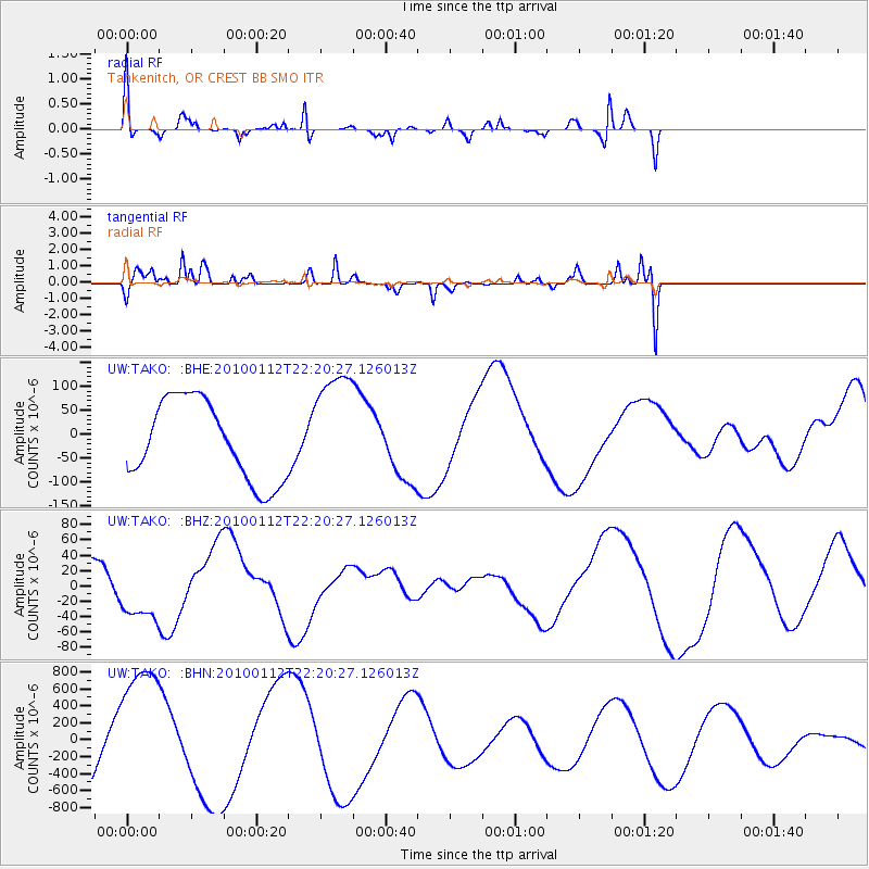
TAKO Tahkenitch, OR CREST BB SMO - Earthquake Result Viewer
*The percent match for this event was below the threshold and hence no stack was calculated.
| Earthquake location: |
Haiti Region |
| Earthquake latitude/longitude: |
18.5/-72.5 |
| Earthquake time(UTC): |
2010/01/12 (012) 22:12:04 GMT |
| Earthquake Depth: |
10 km |
| Earthquake Magnitude: |
5.7 MB |
| Earthquake Catalog/Contributor: |
WHDF/NEIC |
|
| Network: |
UW Pacific Northwest Regional Seismic Network |
| Station: |
TAKO Tahkenitch, OR CREST BB SMO |
| Lat/Lon: |
43.74 N/124.08 W |
| Elevation: |
46 m |
|
| Distance: |
49.9 deg |
| Az: |
312.061 deg |
| Baz: |
103.499 deg |
| Ray Param: |
$rayparam |
*The percent match for this event was below the threshold and hence was not used in the summary stack. |
|
| Radial Match: |
26.454628 % |
| Radial Bump: |
226 |
| Transverse Match: |
22.921589 % |
| Transverse Bump: |
167 |
| SOD ConfigId: |
1 |
| Insert Time: |
2010-03-17 21:37:29.680 +0000 |
| GWidth: |
2.5 |
| Max Bumps: |
400 |
| Tol: |
0.001 |
|
Signal To Noise
| Channel | StoN | STA | LTA |
| UW:TAKO: :BHZ:20100112T22:20:27.126013Z | 1.3959918 | 3.8472317E-5 | 2.7559126E-5 |
| UW:TAKO: :BHN:20100112T22:20:27.126013Z | 1.6915604 | 8.1206305E-4 | 4.8006745E-4 |
| UW:TAKO: :BHE:20100112T22:20:27.126013Z | 1.4543799 | 1.2075513E-4 | 8.30286E-5 |
| Arrivals |
| Ps | |
| PpPs | |
| PsPs/PpSs | |


