You are here: Home > Network List > XA95 - Missouri to Massachusetts Transect Stations List
> Station MM01 North Hampton, Massachusetts > Earthquake Result Viewer
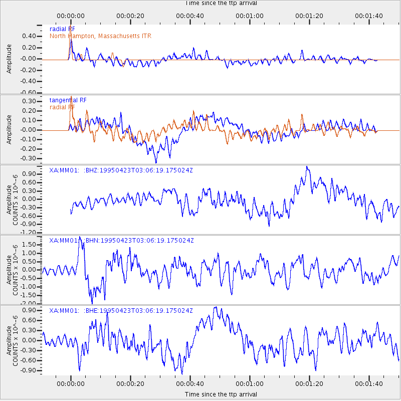
MM01 North Hampton, Massachusetts - Earthquake Result Viewer
*The percent match for this event was below the threshold and hence no stack was calculated.
| Earthquake location: |
Rat Islands, Aleutian Islands |
| Earthquake latitude/longitude: |
51.3/179.7 |
| Earthquake time(UTC): |
1995/04/23 (113) 02:55:54 GMT |
| Earthquake Depth: |
16 km |
| Earthquake Magnitude: |
6.1 MB, 6.4 MS, 6.5 UNKNOWN, 6.7 ML |
| Earthquake Catalog/Contributor: |
WHDF/NEIC |
|
| Network: |
XA Missouri to Massachusetts Transect |
| Station: |
MM01 North Hampton, Massachusetts |
| Lat/Lon: |
42.32 N/72.71 W |
| Elevation: |
122 m |
|
| Distance: |
67.5 deg |
| Az: |
49.911 deg |
| Baz: |
319.682 deg |
| Ray Param: |
$rayparam |
*The percent match for this event was below the threshold and hence was not used in the summary stack. |
|
| Radial Match: |
75.585556 % |
| Radial Bump: |
400 |
| Transverse Match: |
54.14312 % |
| Transverse Bump: |
400 |
| SOD ConfigId: |
4480 |
| Insert Time: |
2010-02-26 17:42:52.280 +0000 |
| GWidth: |
2.5 |
| Max Bumps: |
400 |
| Tol: |
0.001 |
|
Signal To Noise
| Channel | StoN | STA | LTA |
| XA:MM01: :BHN:19950423T03:06:19.175024Z | 6.0019174 | 9.95184E-7 | 1.6581102E-7 |
| XA:MM01: :BHE:19950423T03:06:19.175024Z | 1.9172678 | 3.049373E-7 | 1.5904783E-7 |
| XA:MM01: :BHZ:19950423T03:06:19.175024Z | 2.0874333 | 3.284581E-7 | 1.5735021E-7 |
| Arrivals |
| Ps | |
| PpPs | |
| PsPs/PpSs | |


