You are here: Home > Network List > XA95 - Missouri to Massachusetts Transect Stations List
> Station MM01 North Hampton, Massachusetts > Earthquake Result Viewer
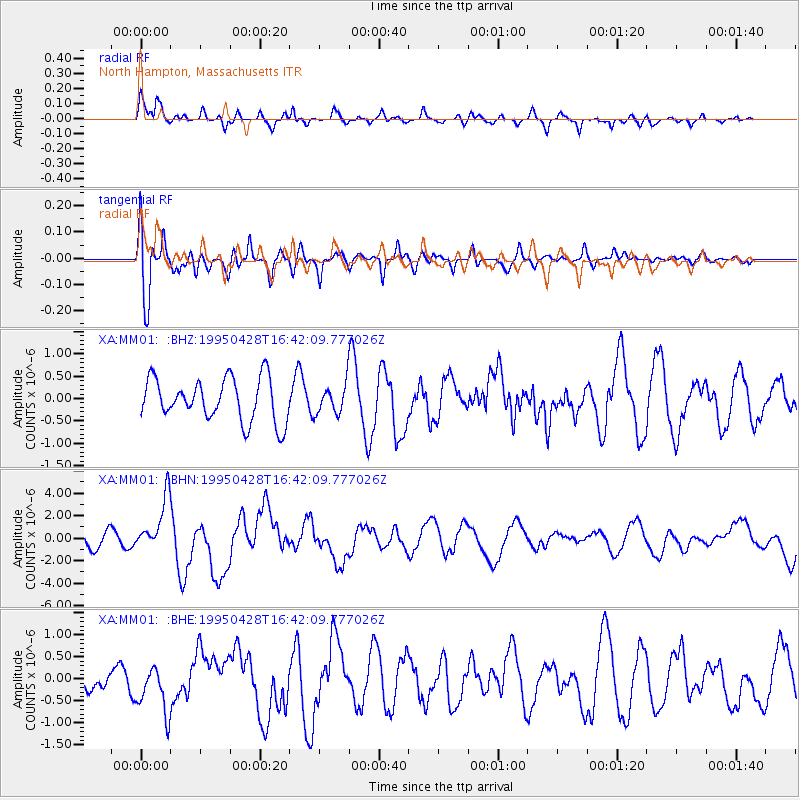
MM01 North Hampton, Massachusetts - Earthquake Result Viewer
*The percent match for this event was below the threshold and hence no stack was calculated.
| Earthquake location: |
Kuril Islands |
| Earthquake latitude/longitude: |
44.1/148.1 |
| Earthquake time(UTC): |
1995/04/28 (118) 16:30:00 GMT |
| Earthquake Depth: |
29 km |
| Earthquake Magnitude: |
6.6 MB, 6.9 MS, 7.0 UNKNOWN, 6.8 MW |
| Earthquake Catalog/Contributor: |
WHDF/NEIC |
|
| Network: |
XA Missouri to Massachusetts Transect |
| Station: |
MM01 North Hampton, Massachusetts |
| Lat/Lon: |
42.32 N/72.71 W |
| Elevation: |
122 m |
|
| Distance: |
86.6 deg |
| Az: |
29.023 deg |
| Baz: |
331.86 deg |
| Ray Param: |
$rayparam |
*The percent match for this event was below the threshold and hence was not used in the summary stack. |
|
| Radial Match: |
68.746346 % |
| Radial Bump: |
400 |
| Transverse Match: |
77.470116 % |
| Transverse Bump: |
400 |
| SOD ConfigId: |
4480 |
| Insert Time: |
2010-02-26 17:42:52.969 +0000 |
| GWidth: |
2.5 |
| Max Bumps: |
400 |
| Tol: |
0.001 |
|
Signal To Noise
| Channel | StoN | STA | LTA |
| XA:MM01: :BHN:19950428T16:42:09.777026Z | 4.256545 | 2.3522998E-6 | 5.5263126E-7 |
| XA:MM01: :BHE:19950428T16:42:09.777026Z | 2.249447 | 5.3958337E-7 | 2.3987377E-7 |
| XA:MM01: :BHZ:19950428T16:42:09.777026Z | 0.6734673 | 3.1993133E-7 | 4.7505105E-7 |
| Arrivals |
| Ps | |
| PpPs | |
| PsPs/PpSs | |


