You are here: Home > Network List > AK - Alaska Regional Network Stations List
> Station E22K Anaktuvuk Pass, AK, USA > Earthquake Result Viewer
E22K Anaktuvuk Pass, AK, USA - Earthquake Result Viewer
| Earthquake location: |
Philippine Islands Region |
| Earthquake latitude/longitude: |
6.2/127.6 |
| Earthquake time(UTC): |
2022/09/12 (255) 08:14:40 GMT |
| Earthquake Depth: |
10 km |
| Earthquake Magnitude: |
5.6 mww |
| Earthquake Catalog/Contributor: |
NEIC PDE/us |
|
| Network: |
AK Alaska Regional Network |
| Station: |
E22K Anaktuvuk Pass, AK, USA |
| Lat/Lon: |
68.13 N/151.81 W |
| Elevation: |
772 m |
|
| Distance: |
80.8 deg |
| Az: |
21.987 deg |
| Baz: |
263.586 deg |
| Ray Param: |
0.048029505 |
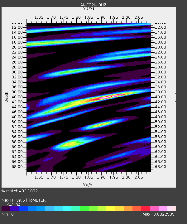
| Estimated Moho Depth: |
39.5 km |
| Estimated Crust Vp/Vs: |
1.94 |
| Assumed Crust Vp: |
6.221 km/s |
| Estimated Crust Vs: |
3.207 km/s |
| Estimated Crust Poisson's Ratio: |
0.32 |
|
| Radial Match: |
83.1002 % |
| Radial Bump: |
400 |
| Transverse Match: |
75.54733 % |
| Transverse Bump: |
400 |
| SOD ConfigId: |
28764291 |
| Insert Time: |
2022-09-26 08:17:47.338 +0000 |
| GWidth: |
2.5 |
| Max Bumps: |
400 |
| Tol: |
0.001 |
|

Signal To Noise
| Channel | StoN | STA | LTA |
| AK:E22K: :BHZ:20220912T08:26:22.400012Z | 11.233371 | 9.258496E-7 | 8.2419575E-8 |
| AK:E22K: :BHN:20220912T08:26:22.400012Z | 1.9835153 | 1.3950702E-7 | 7.033322E-8 |
| AK:E22K: :BHE:20220912T08:26:22.400012Z | 3.3048584 | 2.4180713E-7 | 7.3167165E-8 |
| Arrivals |
| Ps | 6.1 SECOND |
| PpPs | 18 SECOND |
| PsPs/PpSs | 24 SECOND |


