You are here: Home > Network List > AK - Alaska Regional Network Stations List
> Station K27K Chicken, AK, USA > Earthquake Result Viewer
K27K Chicken, AK, USA - Earthquake Result Viewer
| Earthquake location: |
Philippine Islands Region |
| Earthquake latitude/longitude: |
6.2/127.6 |
| Earthquake time(UTC): |
2022/09/12 (255) 08:14:40 GMT |
| Earthquake Depth: |
10 km |
| Earthquake Magnitude: |
5.6 mww |
| Earthquake Catalog/Contributor: |
NEIC PDE/us |
|
| Network: |
AK Alaska Regional Network |
| Station: |
K27K Chicken, AK, USA |
| Lat/Lon: |
64.03 N/142.08 W |
| Elevation: |
732 m |
|
| Distance: |
84.6 deg |
| Az: |
26.245 deg |
| Baz: |
273.026 deg |
| Ray Param: |
0.045337386 |
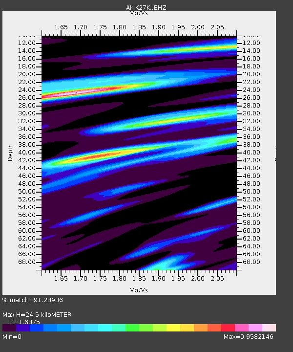
| Estimated Moho Depth: |
24.5 km |
| Estimated Crust Vp/Vs: |
1.69 |
| Assumed Crust Vp: |
6.566 km/s |
| Estimated Crust Vs: |
3.891 km/s |
| Estimated Crust Poisson's Ratio: |
0.23 |
|
| Radial Match: |
91.28936 % |
| Radial Bump: |
400 |
| Transverse Match: |
71.37847 % |
| Transverse Bump: |
400 |
| SOD ConfigId: |
28764291 |
| Insert Time: |
2022-09-26 08:19:18.134 +0000 |
| GWidth: |
2.5 |
| Max Bumps: |
400 |
| Tol: |
0.001 |
|

Signal To Noise
| Channel | StoN | STA | LTA |
| AK:K27K: :BHZ:20220912T08:26:42.299976Z | 21.184202 | 1.7616296E-6 | 8.31577E-8 |
| AK:K27K: :BHN:20220912T08:26:42.299976Z | 3.7400937 | 1.5385066E-7 | 4.113551E-8 |
| AK:K27K: :BHE:20220912T08:26:42.299976Z | 10.959657 | 6.008569E-7 | 5.4824426E-8 |
| Arrivals |
| Ps | 2.6 SECOND |
| PpPs | 9.8 SECOND |
| PsPs/PpSs | 12 SECOND |


