You are here: Home > Network List > IW - Intermountain West Stations List
> Station DLMT Dillon, Montana, USA > Earthquake Result Viewer
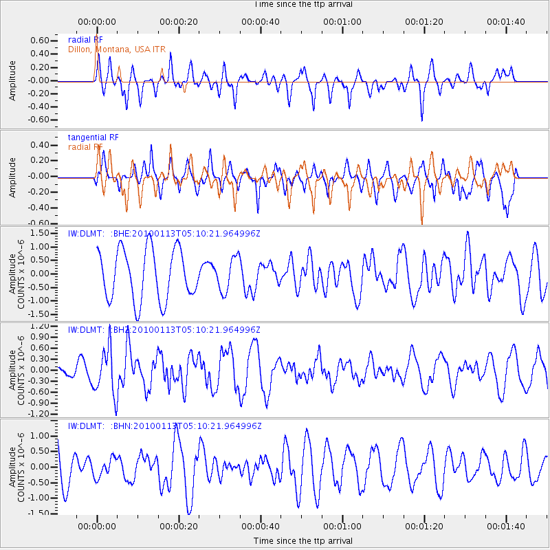
DLMT Dillon, Montana, USA - Earthquake Result Viewer
*The percent match for this event was below the threshold and hence no stack was calculated.
| Earthquake location: |
Haiti Region |
| Earthquake latitude/longitude: |
18.4/-72.9 |
| Earthquake time(UTC): |
2010/01/13 (013) 05:02:57 GMT |
| Earthquake Depth: |
10 km |
| Earthquake Magnitude: |
5.7 MB, 5.6 MS, 5.8 MW, 5.8 MW |
| Earthquake Catalog/Contributor: |
WHDF/NEIC |
|
| Network: |
IW Intermountain West |
| Station: |
DLMT Dillon, Montana, USA |
| Lat/Lon: |
45.36 N/112.60 W |
| Elevation: |
1569 m |
|
| Distance: |
42.5 deg |
| Az: |
318.201 deg |
| Baz: |
116.123 deg |
| Ray Param: |
$rayparam |
*The percent match for this event was below the threshold and hence was not used in the summary stack. |
|
| Radial Match: |
57.310543 % |
| Radial Bump: |
400 |
| Transverse Match: |
58.957836 % |
| Transverse Bump: |
395 |
| SOD ConfigId: |
1 |
| Insert Time: |
2010-03-17 21:46:24.730 +0000 |
| GWidth: |
2.5 |
| Max Bumps: |
400 |
| Tol: |
0.001 |
|
Signal To Noise
| Channel | StoN | STA | LTA |
| IW:DLMT: :BHZ:20100113T05:10:21.964996Z | 2.4421318 | 6.445234E-7 | 2.6391837E-7 |
| IW:DLMT: :BHN:20100113T05:10:21.964996Z | 0.46671876 | 3.0326663E-7 | 6.4978457E-7 |
| IW:DLMT: :BHE:20100113T05:10:21.964996Z | 0.6767357 | 6.316221E-7 | 9.333365E-7 |
| Arrivals |
| Ps | |
| PpPs | |
| PsPs/PpSs | |


