You are here: Home > Network List > TA - USArray Transportable Network (new EarthScope stations) Stations List
> Station 126A Clayton Basin, Artesia, NM, USA > Earthquake Result Viewer
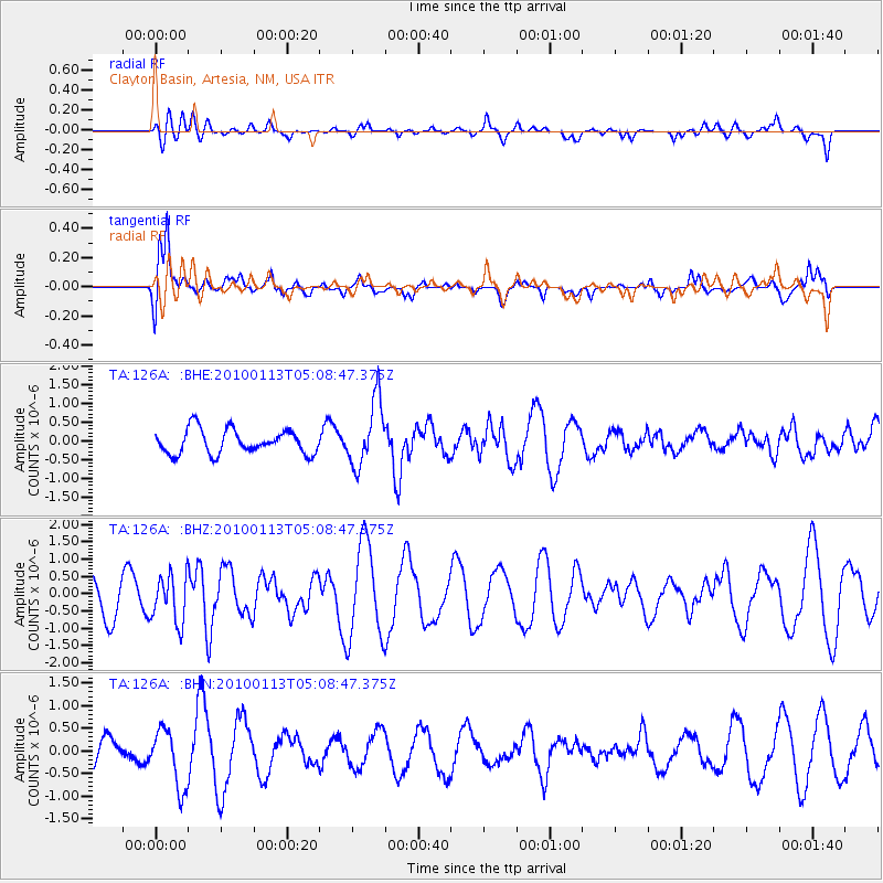
126A Clayton Basin, Artesia, NM, USA - Earthquake Result Viewer
*The percent match for this event was below the threshold and hence no stack was calculated.
| Earthquake location: |
Haiti Region |
| Earthquake latitude/longitude: |
18.4/-72.9 |
| Earthquake time(UTC): |
2010/01/13 (013) 05:02:57 GMT |
| Earthquake Depth: |
10 km |
| Earthquake Magnitude: |
5.7 MB, 5.6 MS, 5.8 MW, 5.8 MW |
| Earthquake Catalog/Contributor: |
WHDF/NEIC |
|
| Network: |
TA USArray Transportable Network (new EarthScope stations) |
| Station: |
126A Clayton Basin, Artesia, NM, USA |
| Lat/Lon: |
32.65 N/104.02 W |
| Elevation: |
1032 m |
|
| Distance: |
31.3 deg |
| Az: |
303.048 deg |
| Baz: |
109.341 deg |
| Ray Param: |
$rayparam |
*The percent match for this event was below the threshold and hence was not used in the summary stack. |
|
| Radial Match: |
35.95348 % |
| Radial Bump: |
400 |
| Transverse Match: |
79.95194 % |
| Transverse Bump: |
400 |
| SOD ConfigId: |
1 |
| Insert Time: |
2010-03-17 21:50:35.632 +0000 |
| GWidth: |
2.5 |
| Max Bumps: |
400 |
| Tol: |
0.001 |
|
Signal To Noise
| Channel | StoN | STA | LTA |
| TA:126A: :BHZ:20100113T05:08:47.375Z | 1.0355045 | 6.793626E-7 | 6.560692E-7 |
| TA:126A: :BHN:20100113T05:08:47.375Z | 1.539676 | 6.488202E-7 | 4.214005E-7 |
| TA:126A: :BHE:20100113T05:08:47.375Z | 2.709904 | 8.6778E-7 | 3.2022538E-7 |
| Arrivals |
| Ps | |
| PpPs | |
| PsPs/PpSs | |


