You are here: Home > Network List > TA - USArray Transportable Network (new EarthScope stations) Stations List
> Station L24A Wheatland, WY, USA > Earthquake Result Viewer
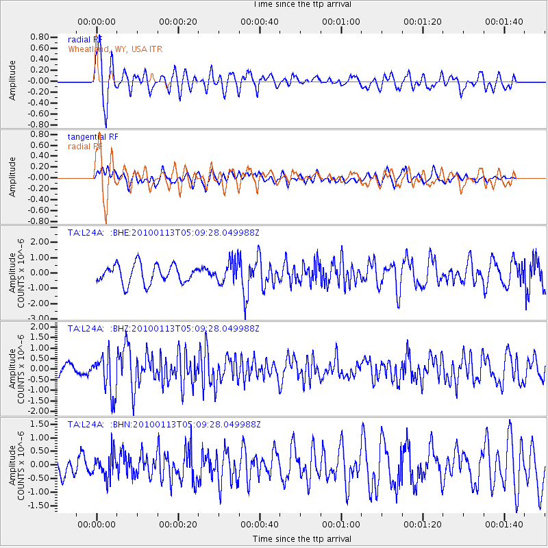
L24A Wheatland, WY, USA - Earthquake Result Viewer
*The percent match for this event was below the threshold and hence no stack was calculated.
| Earthquake location: |
Haiti Region |
| Earthquake latitude/longitude: |
18.4/-72.9 |
| Earthquake time(UTC): |
2010/01/13 (013) 05:02:57 GMT |
| Earthquake Depth: |
10 km |
| Earthquake Magnitude: |
5.7 MB, 5.6 MS, 5.8 MW, 5.8 MW |
| Earthquake Catalog/Contributor: |
WHDF/NEIC |
|
| Network: |
TA USArray Transportable Network (new EarthScope stations) |
| Station: |
L24A Wheatland, WY, USA |
| Lat/Lon: |
42.04 N/104.93 W |
| Elevation: |
1479 m |
|
| Distance: |
36.0 deg |
| Az: |
317.812 deg |
| Baz: |
121.104 deg |
| Ray Param: |
$rayparam |
*The percent match for this event was below the threshold and hence was not used in the summary stack. |
|
| Radial Match: |
68.744354 % |
| Radial Bump: |
400 |
| Transverse Match: |
51.417843 % |
| Transverse Bump: |
400 |
| SOD ConfigId: |
1 |
| Insert Time: |
2010-03-17 21:53:14.240 +0000 |
| GWidth: |
2.5 |
| Max Bumps: |
400 |
| Tol: |
0.001 |
|
Signal To Noise
| Channel | StoN | STA | LTA |
| TA:L24A: :BHZ:20100113T05:09:28.049988Z | 2.9633346 | 9.658545E-7 | 3.2593502E-7 |
| TA:L24A: :BHN:20100113T05:09:28.049988Z | 0.82015383 | 4.309529E-7 | 5.2545374E-7 |
| TA:L24A: :BHE:20100113T05:09:28.049988Z | 1.2410771 | 7.456307E-7 | 6.007932E-7 |
| Arrivals |
| Ps | |
| PpPs | |
| PsPs/PpSs | |


