You are here: Home > Network List > TA - USArray Transportable Network (new EarthScope stations) Stations List
> Station A23A Redstone, MT, USA > Earthquake Result Viewer
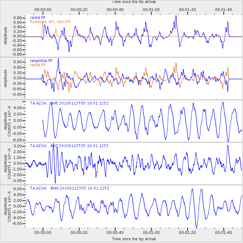
A23A Redstone, MT, USA - Earthquake Result Viewer
*The percent match for this event was below the threshold and hence no stack was calculated.
| Earthquake location: |
Haiti Region |
| Earthquake latitude/longitude: |
18.4/-72.9 |
| Earthquake time(UTC): |
2010/01/13 (013) 05:02:57 GMT |
| Earthquake Depth: |
10 km |
| Earthquake Magnitude: |
5.7 MB, 5.6 MS, 5.8 MW, 5.8 MW |
| Earthquake Catalog/Contributor: |
WHDF/NEIC |
|
| Network: |
TA USArray Transportable Network (new EarthScope stations) |
| Station: |
A23A Redstone, MT, USA |
| Lat/Lon: |
48.96 N/104.88 W |
| Elevation: |
665 m |
|
| Distance: |
40.0 deg |
| Az: |
327.08 deg |
| Baz: |
128.457 deg |
| Ray Param: |
$rayparam |
*The percent match for this event was below the threshold and hence was not used in the summary stack. |
|
| Radial Match: |
42.504963 % |
| Radial Bump: |
303 |
| Transverse Match: |
64.408005 % |
| Transverse Bump: |
389 |
| SOD ConfigId: |
1 |
| Insert Time: |
2010-03-17 21:54:51.021 +0000 |
| GWidth: |
2.5 |
| Max Bumps: |
400 |
| Tol: |
0.001 |
|
Signal To Noise
| Channel | StoN | STA | LTA |
| TA:A23A: :BHZ:20100113T05:10:01.125Z | 2.746707 | 1.1190793E-6 | 4.0742583E-7 |
| TA:A23A: :BHN:20100113T05:10:01.125Z | 0.3344854 | 6.113034E-7 | 1.8275936E-6 |
| TA:A23A: :BHE:20100113T05:10:01.125Z | 0.7651531 | 2.0887344E-6 | 2.7298254E-6 |
| Arrivals |
| Ps | |
| PpPs | |
| PsPs/PpSs | |


