You are here: Home > Network List > XA95 - Missouri to Massachusetts Transect Stations List
> Station MM01 North Hampton, Massachusetts > Earthquake Result Viewer
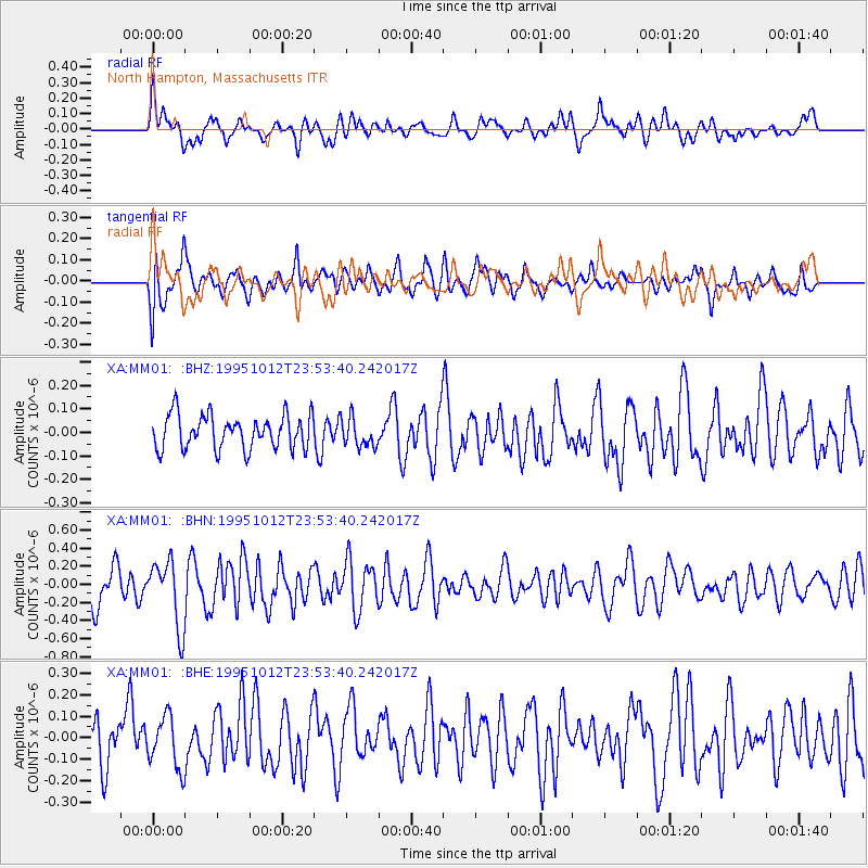
MM01 North Hampton, Massachusetts - Earthquake Result Viewer
*The percent match for this event was below the threshold and hence no stack was calculated.
| Earthquake location: |
Southern East Pacific Rise |
| Earthquake latitude/longitude: |
-35.4/-106.2 |
| Earthquake time(UTC): |
1995/10/12 (285) 23:41:45 GMT |
| Earthquake Depth: |
10 km |
| Earthquake Magnitude: |
5.5 MB, 5.3 MS, 5.9 UNKNOWN |
| Earthquake Catalog/Contributor: |
WHDF/NEIC |
|
| Network: |
XA Missouri to Massachusetts Transect |
| Station: |
MM01 North Hampton, Massachusetts |
| Lat/Lon: |
42.32 N/72.71 W |
| Elevation: |
122 m |
|
| Distance: |
83.2 deg |
| Az: |
24.352 deg |
| Baz: |
207.01 deg |
| Ray Param: |
$rayparam |
*The percent match for this event was below the threshold and hence was not used in the summary stack. |
|
| Radial Match: |
61.196995 % |
| Radial Bump: |
400 |
| Transverse Match: |
61.87475 % |
| Transverse Bump: |
400 |
| SOD ConfigId: |
4480 |
| Insert Time: |
2010-02-26 17:42:56.594 +0000 |
| GWidth: |
2.5 |
| Max Bumps: |
400 |
| Tol: |
0.001 |
|
Signal To Noise
| Channel | StoN | STA | LTA |
| XA:MM01: :BHN:19951012T23:53:40.242017Z | 2.65327 | 3.69125E-7 | 1.3912077E-7 |
| XA:MM01: :BHE:19951012T23:53:40.242017Z | 1.0359511 | 1.2195038E-7 | 1.17718265E-7 |
| XA:MM01: :BHZ:19951012T23:53:40.242017Z | 0.8587153 | 6.141478E-8 | 7.151937E-8 |
| Arrivals |
| Ps | |
| PpPs | |
| PsPs/PpSs | |


