You are here: Home > Network List > TA - USArray Transportable Network (new EarthScope stations) Stations List
> Station F22A Rosebud, MT, USA > Earthquake Result Viewer
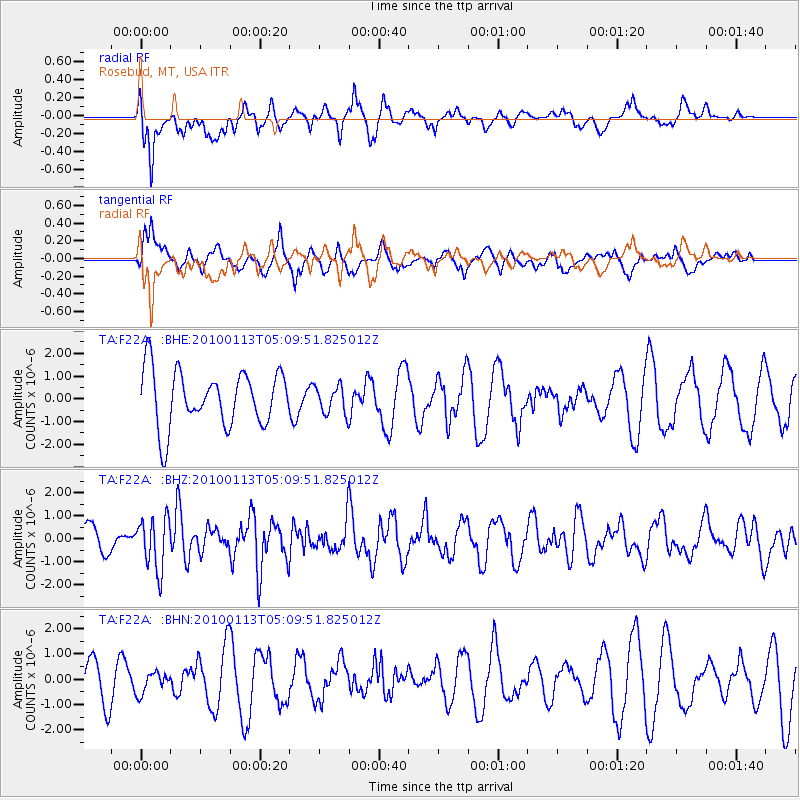
F22A Rosebud, MT, USA - Earthquake Result Viewer
*The percent match for this event was below the threshold and hence no stack was calculated.
| Earthquake location: |
Haiti Region |
| Earthquake latitude/longitude: |
18.4/-72.9 |
| Earthquake time(UTC): |
2010/01/13 (013) 05:02:57 GMT |
| Earthquake Depth: |
10 km |
| Earthquake Magnitude: |
5.7 MB, 5.6 MS, 5.8 MW, 5.8 MW |
| Earthquake Catalog/Contributor: |
WHDF/NEIC |
|
| Network: |
TA USArray Transportable Network (new EarthScope stations) |
| Station: |
F22A Rosebud, MT, USA |
| Lat/Lon: |
45.78 N/106.26 W |
| Elevation: |
882 m |
|
| Distance: |
38.8 deg |
| Az: |
322.158 deg |
| Baz: |
123.641 deg |
| Ray Param: |
$rayparam |
*The percent match for this event was below the threshold and hence was not used in the summary stack. |
|
| Radial Match: |
60.817352 % |
| Radial Bump: |
400 |
| Transverse Match: |
46.490574 % |
| Transverse Bump: |
400 |
| SOD ConfigId: |
1 |
| Insert Time: |
2010-03-17 21:56:09.337 +0000 |
| GWidth: |
2.5 |
| Max Bumps: |
400 |
| Tol: |
0.001 |
|
Signal To Noise
| Channel | StoN | STA | LTA |
| TA:F22A: :BHZ:20100113T05:09:51.825012Z | 1.7330801 | 1.1122073E-6 | 6.417518E-7 |
| TA:F22A: :BHN:20100113T05:09:51.825012Z | 0.5336573 | 4.1296533E-7 | 7.7383993E-7 |
| TA:F22A: :BHE:20100113T05:09:51.825012Z | 0.500692 | 6.12436E-7 | 1.2231791E-6 |
| Arrivals |
| Ps | |
| PpPs | |
| PsPs/PpSs | |


