You are here: Home > Network List > TA - USArray Transportable Network (new EarthScope stations) Stations List
> Station V27A Dan Oppilter Farms, Dalhart, TX, USA > Earthquake Result Viewer
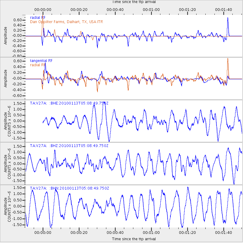
V27A Dan Oppilter Farms, Dalhart, TX, USA - Earthquake Result Viewer
*The percent match for this event was below the threshold and hence no stack was calculated.
| Earthquake location: |
Haiti Region |
| Earthquake latitude/longitude: |
18.4/-72.9 |
| Earthquake time(UTC): |
2010/01/13 (013) 05:02:57 GMT |
| Earthquake Depth: |
10 km |
| Earthquake Magnitude: |
5.7 MB, 5.6 MS, 5.8 MW, 5.8 MW |
| Earthquake Catalog/Contributor: |
WHDF/NEIC |
|
| Network: |
TA USArray Transportable Network (new EarthScope stations) |
| Station: |
V27A Dan Oppilter Farms, Dalhart, TX, USA |
| Lat/Lon: |
35.76 N/102.84 W |
| Elevation: |
1228 m |
|
| Distance: |
31.6 deg |
| Az: |
309.261 deg |
| Baz: |
115.305 deg |
| Ray Param: |
$rayparam |
*The percent match for this event was below the threshold and hence was not used in the summary stack. |
|
| Radial Match: |
54.298916 % |
| Radial Bump: |
400 |
| Transverse Match: |
58.56221 % |
| Transverse Bump: |
400 |
| SOD ConfigId: |
1 |
| Insert Time: |
2010-03-17 21:58:37.727 +0000 |
| GWidth: |
2.5 |
| Max Bumps: |
400 |
| Tol: |
0.001 |
|
Signal To Noise
| Channel | StoN | STA | LTA |
| TA:V27A: :BHZ:20100113T05:08:49.750Z | 1.1280372 | 4.8823676E-7 | 4.3281975E-7 |
| TA:V27A: :BHN:20100113T05:08:49.750Z | 1.4269466 | 9.3051904E-7 | 6.52105E-7 |
| TA:V27A: :BHE:20100113T05:08:49.750Z | 3.7450073 | 1.1172107E-6 | 2.9832003E-7 |
| Arrivals |
| Ps | |
| PpPs | |
| PsPs/PpSs | |


