You are here: Home > Network List > TA - USArray Transportable Network (new EarthScope stations) Stations List
> Station I28A Midland, SD, USA > Earthquake Result Viewer
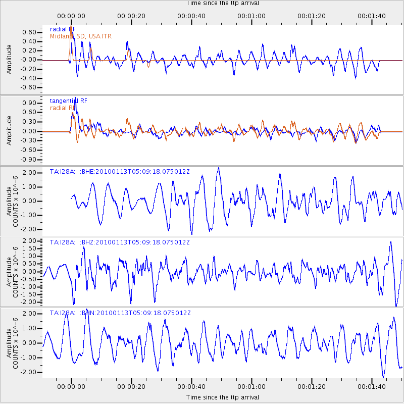
I28A Midland, SD, USA - Earthquake Result Viewer
*The percent match for this event was below the threshold and hence no stack was calculated.
| Earthquake location: |
Haiti Region |
| Earthquake latitude/longitude: |
18.4/-72.9 |
| Earthquake time(UTC): |
2010/01/13 (013) 05:02:57 GMT |
| Earthquake Depth: |
10 km |
| Earthquake Magnitude: |
5.7 MB, 5.6 MS, 5.8 MW, 5.8 MW |
| Earthquake Catalog/Contributor: |
WHDF/NEIC |
|
| Network: |
TA USArray Transportable Network (new EarthScope stations) |
| Station: |
I28A Midland, SD, USA |
| Lat/Lon: |
44.00 N/101.17 W |
| Elevation: |
655 m |
|
| Distance: |
34.9 deg |
| Az: |
323.289 deg |
| Baz: |
128.127 deg |
| Ray Param: |
$rayparam |
*The percent match for this event was below the threshold and hence was not used in the summary stack. |
|
| Radial Match: |
56.978336 % |
| Radial Bump: |
400 |
| Transverse Match: |
74.94946 % |
| Transverse Bump: |
400 |
| SOD ConfigId: |
1 |
| Insert Time: |
2010-03-17 22:00:47.625 +0000 |
| GWidth: |
2.5 |
| Max Bumps: |
400 |
| Tol: |
0.001 |
|
Signal To Noise
| Channel | StoN | STA | LTA |
| TA:I28A: :BHZ:20100113T05:09:18.075012Z | 2.150813 | 9.816595E-7 | 4.564132E-7 |
| TA:I28A: :BHN:20100113T05:09:18.075012Z | 1.194166 | 1.0262798E-6 | 8.5941144E-7 |
| TA:I28A: :BHE:20100113T05:09:18.075012Z | 1.7150966 | 1.1407287E-6 | 6.651105E-7 |
| Arrivals |
| Ps | |
| PpPs | |
| PsPs/PpSs | |


