You are here: Home > Network List > XA95 - Missouri to Massachusetts Transect Stations List
> Station MM01 North Hampton, Massachusetts > Earthquake Result Viewer
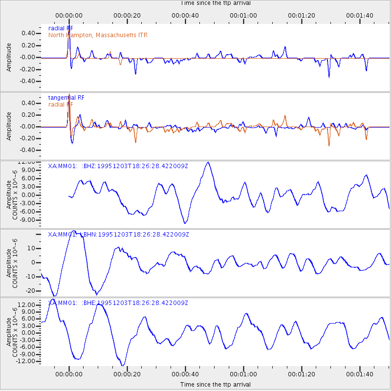
MM01 North Hampton, Massachusetts - Earthquake Result Viewer
*The percent match for this event was below the threshold and hence no stack was calculated.
| Earthquake location: |
East Of Kuril Islands |
| Earthquake latitude/longitude: |
44.8/150.7 |
| Earthquake time(UTC): |
1995/12/03 (337) 18:14:27 GMT |
| Earthquake Depth: |
33 km |
| Earthquake Magnitude: |
6.4 MB, 6.6 MS |
| Earthquake Catalog/Contributor: |
WHDF/NEIC |
|
| Network: |
XA Missouri to Massachusetts Transect |
| Station: |
MM01 North Hampton, Massachusetts |
| Lat/Lon: |
42.32 N/72.71 W |
| Elevation: |
122 m |
|
| Distance: |
84.9 deg |
| Az: |
30.768 deg |
| Baz: |
330.615 deg |
| Ray Param: |
$rayparam |
*The percent match for this event was below the threshold and hence was not used in the summary stack. |
|
| Radial Match: |
81.455894 % |
| Radial Bump: |
316 |
| Transverse Match: |
69.7486 % |
| Transverse Bump: |
400 |
| SOD ConfigId: |
4480 |
| Insert Time: |
2010-02-26 17:42:58.821 +0000 |
| GWidth: |
2.5 |
| Max Bumps: |
400 |
| Tol: |
0.001 |
|
Signal To Noise
| Channel | StoN | STA | LTA |
| XA:MM01: :BHN:19951203T18:26:28.422009Z | 1.7466463 | 1.9652362E-5 | 1.1251484E-5 |
| XA:MM01: :BHE:19951203T18:26:28.422009Z | 1.1711351 | 7.3175315E-6 | 6.248239E-6 |
| XA:MM01: :BHZ:19951203T18:26:28.422009Z | 0.6398214 | 2.5321458E-6 | 3.957582E-6 |
| Arrivals |
| Ps | |
| PpPs | |
| PsPs/PpSs | |


