You are here: Home > Network List > US - United States National Seismic Network Stations List
> Station WRAK Wrangell Island, Southeastern Alaska, Alaska, USA > Earthquake Result Viewer
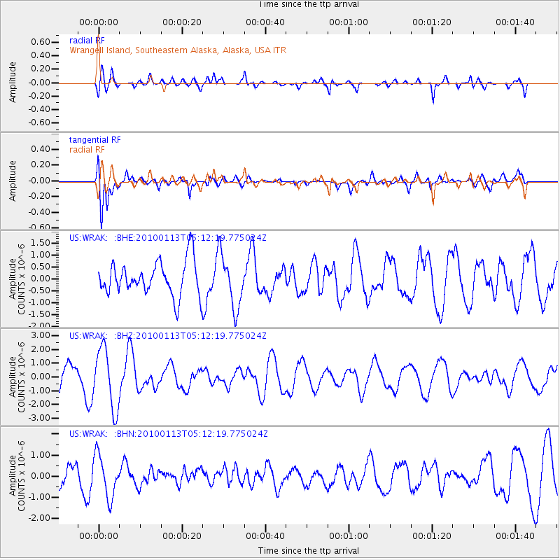
WRAK Wrangell Island, Southeastern Alaska, Alaska, USA - Earthquake Result Viewer
*The percent match for this event was below the threshold and hence no stack was calculated.
| Earthquake location: |
Haiti Region |
| Earthquake latitude/longitude: |
18.4/-72.9 |
| Earthquake time(UTC): |
2010/01/13 (013) 05:02:57 GMT |
| Earthquake Depth: |
10 km |
| Earthquake Magnitude: |
5.7 MB, 5.6 MS, 5.8 MW, 5.8 MW |
| Earthquake Catalog/Contributor: |
WHDF/NEIC |
|
| Network: |
US United States National Seismic Network |
| Station: |
WRAK Wrangell Island, Southeastern Alaska, Alaska, USA |
| Lat/Lon: |
56.42 N/132.35 W |
| Elevation: |
81 m |
|
| Distance: |
58.1 deg |
| Az: |
325.684 deg |
| Baz: |
105.536 deg |
| Ray Param: |
$rayparam |
*The percent match for this event was below the threshold and hence was not used in the summary stack. |
|
| Radial Match: |
66.1972 % |
| Radial Bump: |
400 |
| Transverse Match: |
73.13198 % |
| Transverse Bump: |
400 |
| SOD ConfigId: |
1 |
| Insert Time: |
2010-03-17 22:05:48.264 +0000 |
| GWidth: |
2.5 |
| Max Bumps: |
400 |
| Tol: |
0.001 |
|
Signal To Noise
| Channel | StoN | STA | LTA |
| US:WRAK: :BHZ:20100113T05:12:19.775024Z | 2.4306016 | 2.2486747E-6 | 9.2515154E-7 |
| US:WRAK: :BHN:20100113T05:12:19.775024Z | 1.8989117 | 1.0113795E-6 | 5.3261004E-7 |
| US:WRAK: :BHE:20100113T05:12:19.775024Z | 1.5098301 | 1.0924073E-6 | 7.235299E-7 |
| Arrivals |
| Ps | |
| PpPs | |
| PsPs/PpSs | |


