You are here: Home > Network List > UW - Pacific Northwest Regional Seismic Network Stations List
> Station UMAT Pilot Rock, OR, USA > Earthquake Result Viewer
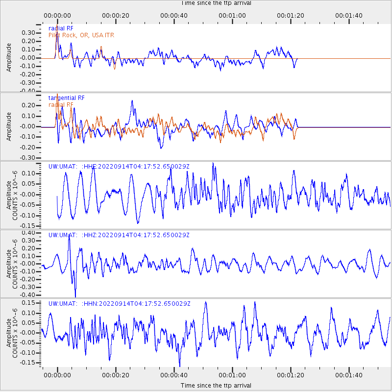
UMAT Pilot Rock, OR, USA - Earthquake Result Viewer
*The percent match for this event was below the threshold and hence no stack was calculated.
| Earthquake location: |
South Of Mariana Islands |
| Earthquake latitude/longitude: |
12.0/143.6 |
| Earthquake time(UTC): |
2022/09/14 (257) 04:05:42 GMT |
| Earthquake Depth: |
27 km |
| Earthquake Magnitude: |
5.3 Mww |
| Earthquake Catalog/Contributor: |
NEIC PDE/us |
|
| Network: |
UW Pacific Northwest Regional Seismic Network |
| Station: |
UMAT Pilot Rock, OR, USA |
| Lat/Lon: |
45.29 N/118.96 W |
| Elevation: |
1318 m |
|
| Distance: |
86.7 deg |
| Az: |
44.512 deg |
| Baz: |
283.664 deg |
| Ray Param: |
$rayparam |
*The percent match for this event was below the threshold and hence was not used in the summary stack. |
|
| Radial Match: |
49.98371 % |
| Radial Bump: |
400 |
| Transverse Match: |
56.27057 % |
| Transverse Bump: |
400 |
| SOD ConfigId: |
28764291 |
| Insert Time: |
2022-09-28 04:26:41.792 +0000 |
| GWidth: |
2.5 |
| Max Bumps: |
400 |
| Tol: |
0.001 |
|
Signal To Noise
| Channel | StoN | STA | LTA |
| UW:UMAT: :HHZ:20220914T04:17:52.650029Z | 2.9744365 | 1.3314695E-7 | 4.476376E-8 |
| UW:UMAT: :HHN:20220914T04:17:52.650029Z | 0.6564742 | 2.9107598E-8 | 4.433929E-8 |
| UW:UMAT: :HHE:20220914T04:17:52.650029Z | 0.6934503 | 4.427794E-8 | 6.3851644E-8 |
| Arrivals |
| Ps | |
| PpPs | |
| PsPs/PpSs | |


