You are here: Home > Network List > WY - Yellowstone Wyoming Seismic Network Stations List
> Station YHH Holmes Hill, YNP, WY, USA > Earthquake Result Viewer
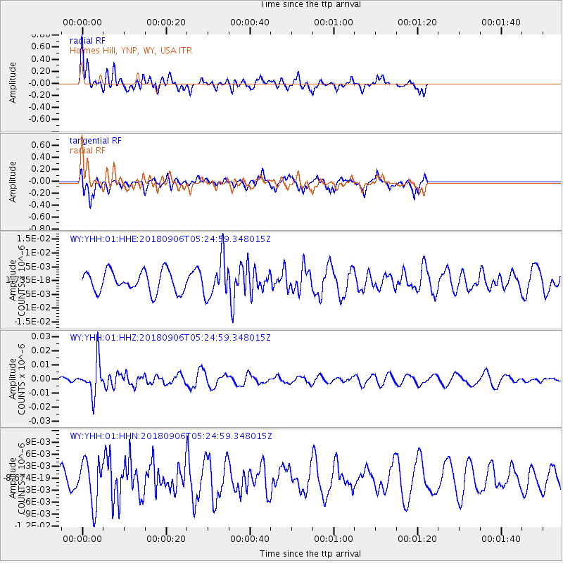
YHH Holmes Hill, YNP, WY, USA - Earthquake Result Viewer
*The percent match for this event was below the threshold and hence no stack was calculated.
| Earthquake location: |
Fiji Islands Region |
| Earthquake latitude/longitude: |
-18.0/-178.5 |
| Earthquake time(UTC): |
2018/09/06 (249) 05:13:39 GMT |
| Earthquake Depth: |
531 km |
| Earthquake Magnitude: |
5.5 Mww |
| Earthquake Catalog/Contributor: |
NEIC PDE/us |
|
| Network: |
WY Yellowstone Wyoming Seismic Network |
| Station: |
YHH Holmes Hill, YNP, WY, USA |
| Lat/Lon: |
44.79 N/110.85 W |
| Elevation: |
2717 m |
|
| Distance: |
87.6 deg |
| Az: |
41.246 deg |
| Baz: |
241.794 deg |
| Ray Param: |
$rayparam |
*The percent match for this event was below the threshold and hence was not used in the summary stack. |
|
| Radial Match: |
62.959557 % |
| Radial Bump: |
400 |
| Transverse Match: |
57.63906 % |
| Transverse Bump: |
369 |
| SOD ConfigId: |
2825771 |
| Insert Time: |
2018-09-20 05:32:37.681 +0000 |
| GWidth: |
2.5 |
| Max Bumps: |
400 |
| Tol: |
0.001 |
|
Signal To Noise
| Channel | StoN | STA | LTA |
| WY:YHH:01:HHZ:20180906T05:24:59.348015Z | 7.049164 | 1.2273511E-8 | 1.74113E-9 |
| WY:YHH:01:HHN:20180906T05:24:59.348015Z | 2.547162 | 5.599175E-9 | 2.1982014E-9 |
| WY:YHH:01:HHE:20180906T05:24:59.348015Z | 1.8665521 | 7.0117605E-9 | 3.7565306E-9 |
| Arrivals |
| Ps | |
| PpPs | |
| PsPs/PpSs | |


