You are here: Home > Network List > AK - Alaska Regional Network Stations List
> Station K13K Kusilvak Mountain, AK, USA > Earthquake Result Viewer
K13K Kusilvak Mountain, AK, USA - Earthquake Result Viewer
| Earthquake location: |
Samoa Islands Region |
| Earthquake latitude/longitude: |
-16.9/-168.8 |
| Earthquake time(UTC): |
2022/09/14 (257) 05:08:06 GMT |
| Earthquake Depth: |
10 km |
| Earthquake Magnitude: |
6.0 Mi |
| Earthquake Catalog/Contributor: |
NEIC PDE/pt |
|
| Network: |
AK Alaska Regional Network |
| Station: |
K13K Kusilvak Mountain, AK, USA |
| Lat/Lon: |
61.93 N/164.66 W |
| Elevation: |
204 m |
|
| Distance: |
78.6 deg |
| Az: |
1.987 deg |
| Baz: |
184.025 deg |
| Ray Param: |
0.04950094 |
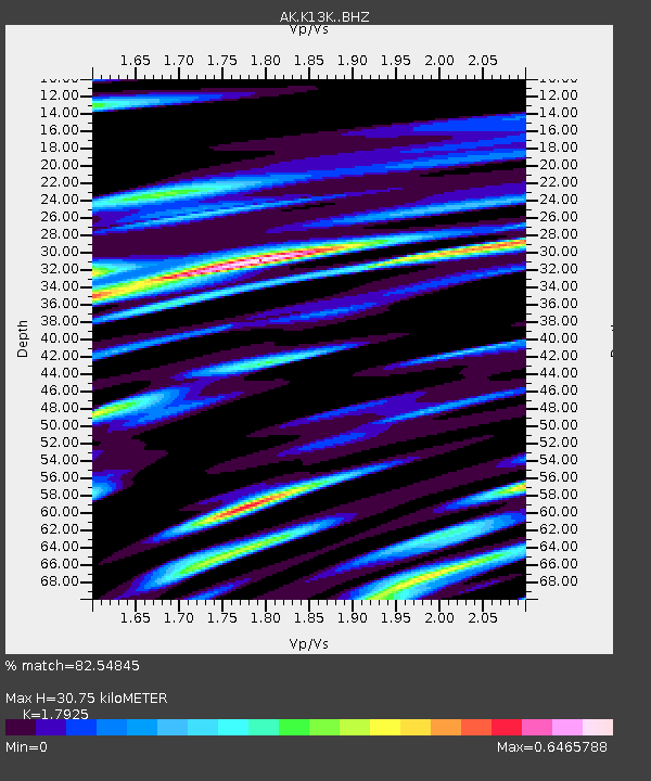
| Estimated Moho Depth: |
30.75 km |
| Estimated Crust Vp/Vs: |
1.79 |
| Assumed Crust Vp: |
6.1 km/s |
| Estimated Crust Vs: |
3.403 km/s |
| Estimated Crust Poisson's Ratio: |
0.27 |
|
| Radial Match: |
82.54845 % |
| Radial Bump: |
400 |
| Transverse Match: |
63.485287 % |
| Transverse Bump: |
400 |
| SOD ConfigId: |
28764291 |
| Insert Time: |
2022-09-28 05:13:00.908 +0000 |
| GWidth: |
2.5 |
| Max Bumps: |
400 |
| Tol: |
0.001 |
|

Signal To Noise
| Channel | StoN | STA | LTA |
| AK:K13K: :BHZ:20220914T05:19:36.679993Z | 7.6120443 | 9.035048E-7 | 1.1869412E-7 |
| AK:K13K: :BHN:20220914T05:19:36.679993Z | 3.670936 | 3.28413E-7 | 8.9463015E-8 |
| AK:K13K: :BHE:20220914T05:19:36.679993Z | 1.4209757 | 1.1827975E-7 | 8.32384E-8 |
| Arrivals |
| Ps | 4.1 SECOND |
| PpPs | 14 SECOND |
| PsPs/PpSs | 18 SECOND |


