You are here: Home > Network List > CC - Cascade Chain Volcano Monitoring Stations List
> Station BRSP Barrett Spur > Earthquake Result Viewer
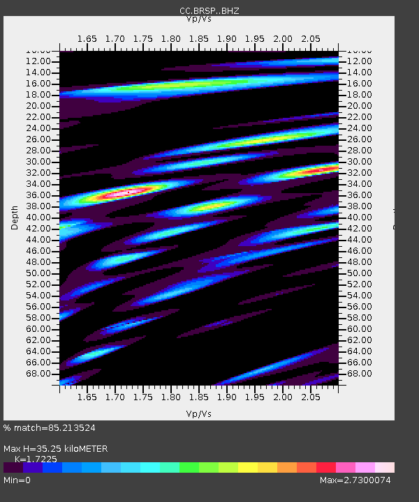
BRSP Barrett Spur - Earthquake Result Viewer
| Earthquake location: |
Samoa Islands Region |
| Earthquake latitude/longitude: |
-16.9/-168.8 |
| Earthquake time(UTC): |
2022/09/14 (257) 05:08:06 GMT |
| Earthquake Depth: |
10 km |
| Earthquake Magnitude: |
6.0 Mi |
| Earthquake Catalog/Contributor: |
NEIC PDE/pt |
|
| Network: |
CC Cascade Chain Volcano Monitoring |
| Station: |
BRSP Barrett Spur |
| Lat/Lon: |
45.40 N/121.71 W |
| Elevation: |
2080 m |
|
| Distance: |
75.3 deg |
| Az: |
32.232 deg |
| Baz: |
226.443 deg |
| Ray Param: |
0.05177767 |
| Estimated Moho Depth: |
35.25 km |
| Estimated Crust Vp/Vs: |
1.72 |
| Assumed Crust Vp: |
6.597 km/s |
| Estimated Crust Vs: |
3.83 km/s |
| Estimated Crust Poisson's Ratio: |
0.25 |
|
| Radial Match: |
85.213524 % |
| Radial Bump: |
400 |
| Transverse Match: |
81.97169 % |
| Transverse Bump: |
400 |
| SOD ConfigId: |
28764291 |
| Insert Time: |
2022-09-28 05:20:35.143 +0000 |
| GWidth: |
2.5 |
| Max Bumps: |
400 |
| Tol: |
0.001 |
|

Signal To Noise
| Channel | StoN | STA | LTA |
| CC:BRSP: :BHZ:20220914T05:19:17.73999Z | 12.0790205 | 7.644761E-7 | 6.3289576E-8 |
| CC:BRSP: :BHN:20220914T05:19:17.73999Z | 5.3754525 | 4.5014596E-7 | 8.3741035E-8 |
| CC:BRSP: :BHE:20220914T05:19:17.73999Z | 3.5754306 | 4.8272256E-7 | 1.3501104E-7 |
| Arrivals |
| Ps | 4.0 SECOND |
| PpPs | 14 SECOND |
| PsPs/PpSs | 18 SECOND |


