You are here: Home > Network List > KN - Kyrgyz Seismic Telemetry Network Stations List
> Station TKM2 KN.TKM2 > Earthquake Result Viewer
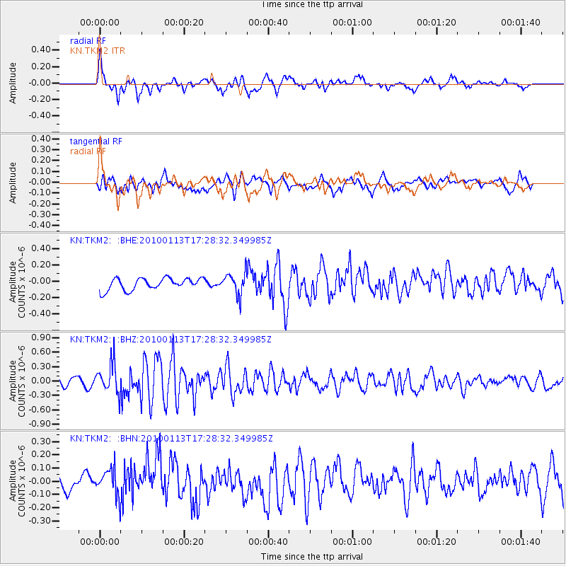
TKM2 KN.TKM2 - Earthquake Result Viewer
*The percent match for this event was below the threshold and hence no stack was calculated.
| Earthquake location: |
Irian Jaya Region, Indonesia |
| Earthquake latitude/longitude: |
-0.7/133.3 |
| Earthquake time(UTC): |
2010/01/13 (013) 17:18:07 GMT |
| Earthquake Depth: |
10 km |
| Earthquake Magnitude: |
5.7 MB, 5.5 MS, 5.7 MW, 5.6 MW |
| Earthquake Catalog/Contributor: |
WHDF/NEIC |
|
| Network: |
KN Kyrgyz Seismic Telemetry Network |
| Station: |
TKM2 KN.TKM2 |
| Lat/Lon: |
42.92 N/75.60 E |
| Elevation: |
2020 m |
|
| Distance: |
67.4 deg |
| Az: |
317.722 deg |
| Baz: |
113.689 deg |
| Ray Param: |
$rayparam |
*The percent match for this event was below the threshold and hence was not used in the summary stack. |
|
| Radial Match: |
69.82491 % |
| Radial Bump: |
400 |
| Transverse Match: |
56.410217 % |
| Transverse Bump: |
400 |
| SOD ConfigId: |
1 |
| Insert Time: |
2010-03-17 22:54:36.859 +0000 |
| GWidth: |
2.5 |
| Max Bumps: |
400 |
| Tol: |
0.001 |
|
Signal To Noise
| Channel | StoN | STA | LTA |
| KN:TKM2: :BHZ:20100113T17:28:32.349985Z | 4.4013844 | 3.1342344E-7 | 7.1210195E-8 |
| KN:TKM2: :BHN:20100113T17:28:32.349985Z | 1.6400336 | 1.0841535E-7 | 6.6105564E-8 |
| KN:TKM2: :BHE:20100113T17:28:32.349985Z | 1.9214836 | 1.3926665E-7 | 7.247871E-8 |
| Arrivals |
| Ps | |
| PpPs | |
| PsPs/PpSs | |


