You are here: Home > Network List > GS - US Geological Survey Networks Stations List
> Station KAN01 Ward Farm, Argonia, KS, USA > Earthquake Result Viewer
KAN01 Ward Farm, Argonia, KS, USA - Earthquake Result Viewer
| Earthquake location: |
Fiji Islands |
| Earthquake latitude/longitude: |
-18.4/179.5 |
| Earthquake time(UTC): |
2018/09/06 (249) 15:49:17 GMT |
| Earthquake Depth: |
669 km |
| Earthquake Magnitude: |
8.1 Mi |
| Earthquake Catalog/Contributor: |
NEIC PDE/at |
|
| Network: |
GS US Geological Survey Networks |
| Station: |
KAN01 Ward Farm, Argonia, KS, USA |
| Lat/Lon: |
37.15 N/97.76 W |
| Elevation: |
360 m |
|
| Distance: |
95.3 deg |
| Az: |
52.75 deg |
| Baz: |
251.082 deg |
| Ray Param: |
0.040071283 |
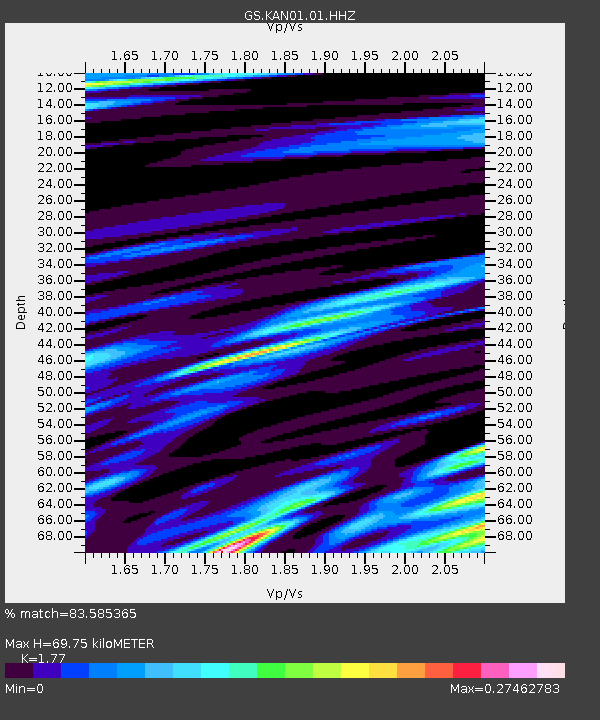
| Estimated Moho Depth: |
69.75 km |
| Estimated Crust Vp/Vs: |
1.77 |
| Assumed Crust Vp: |
6.483 km/s |
| Estimated Crust Vs: |
3.662 km/s |
| Estimated Crust Poisson's Ratio: |
0.27 |
|
| Radial Match: |
83.585365 % |
| Radial Bump: |
400 |
| Transverse Match: |
88.12176 % |
| Transverse Bump: |
400 |
| SOD ConfigId: |
2825771 |
| Insert Time: |
2018-09-20 15:54:14.801 +0000 |
| GWidth: |
2.5 |
| Max Bumps: |
400 |
| Tol: |
0.001 |
|

Signal To Noise
| Channel | StoN | STA | LTA |
| GS:KAN01:01:HHZ:20180906T16:01:00.409973Z | 3.224807 | 4.0737248E-7 | 1.2632461E-7 |
| GS:KAN01:01:HHN:20180906T16:01:00.409973Z | 0.99808836 | 3.339068E-7 | 3.3454634E-7 |
| GS:KAN01:01:HHE:20180906T16:01:00.409973Z | 0.6440325 | 4.0233664E-7 | 6.247148E-7 |
| Arrivals |
| Ps | 8.4 SECOND |
| PpPs | 29 SECOND |
| PsPs/PpSs | 38 SECOND |


