You are here: Home > Network List > GS - US Geological Survey Networks Stations List
> Station OK051 E0350 and S34600 roads, Ralston OK > Earthquake Result Viewer
OK051 E0350 and S34600 roads, Ralston OK - Earthquake Result Viewer
| Earthquake location: |
Samoa Islands Region |
| Earthquake latitude/longitude: |
-16.9/-168.8 |
| Earthquake time(UTC): |
2022/09/14 (257) 05:08:06 GMT |
| Earthquake Depth: |
10 km |
| Earthquake Magnitude: |
6.0 Mi |
| Earthquake Catalog/Contributor: |
NEIC PDE/pt |
|
| Network: |
GS US Geological Survey Networks |
| Station: |
OK051 E0350 and S34600 roads, Ralston OK |
| Lat/Lon: |
36.50 N/96.84 W |
| Elevation: |
263 m |
|
| Distance: |
86.1 deg |
| Az: |
50.156 deg |
| Baz: |
245.815 deg |
| Ray Param: |
0.04428862 |
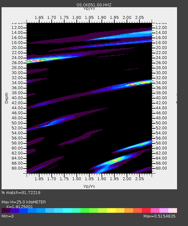
| Estimated Moho Depth: |
25.0 km |
| Estimated Crust Vp/Vs: |
1.61 |
| Assumed Crust Vp: |
6.483 km/s |
| Estimated Crust Vs: |
4.02 km/s |
| Estimated Crust Poisson's Ratio: |
0.19 |
|
| Radial Match: |
81.72218 % |
| Radial Bump: |
400 |
| Transverse Match: |
66.20743 % |
| Transverse Bump: |
400 |
| SOD ConfigId: |
28764291 |
| Insert Time: |
2022-09-28 05:27:36.920 +0000 |
| GWidth: |
2.5 |
| Max Bumps: |
400 |
| Tol: |
0.001 |
|
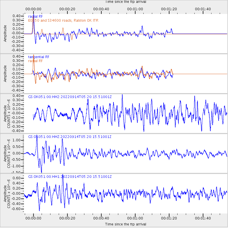
Signal To Noise
| Channel | StoN | STA | LTA |
| GS:OK051:00:HHZ:20220914T05:20:15.51001Z | 6.1235957 | 6.4772723E-7 | 1.05775634E-7 |
| GS:OK051:00:HH1:20220914T05:20:15.51001Z | 3.0926442 | 2.5157507E-7 | 8.134627E-8 |
| GS:OK051:00:HH2:20220914T05:20:15.51001Z | 2.0773513 | 1.791718E-7 | 8.6250125E-8 |
| Arrivals |
| Ps | 2.4 SECOND |
| PpPs | 9.8 SECOND |
| PsPs/PpSs | 12 SECOND |


