You are here: Home > Network List > IU - Global Seismograph Network (GSN - IRIS/USGS) Stations List
> Station JOHN Johnston Island, USA > Earthquake Result Viewer
JOHN Johnston Island, USA - Earthquake Result Viewer

| Earthquake location: |
Fiji Islands |
| Earthquake latitude/longitude: |
-18.4/179.5 |
| Earthquake time(UTC): |
2018/09/06 (249) 15:49:17 GMT |
| Earthquake Depth: |
669 km |
| Earthquake Magnitude: |
8.1 Mi |
| Earthquake Catalog/Contributor: |
NEIC PDE/at |
|
| Network: |
IU Global Seismograph Network (GSN - IRIS/USGS) |
| Station: |
JOHN Johnston Island, USA |
| Lat/Lon: |
16.73 N/169.53 W |
| Elevation: |
2.0 m |
|
| Distance: |
36.5 deg |
| Az: |
17.833 deg |
| Baz: |
197.666 deg |
| Ray Param: |
0.07295135 |
| Estimated Moho Depth: |
10.75 km |
| Estimated Crust Vp/Vs: |
1.71 |
| Assumed Crust Vp: |
4.24 km/s |
| Estimated Crust Vs: |
2.476 km/s |
| Estimated Crust Poisson's Ratio: |
0.24 |
|
| Radial Match: |
86.97798 % |
| Radial Bump: |
400 |
| Transverse Match: |
86.08368 % |
| Transverse Bump: |
400 |
| SOD ConfigId: |
2825771 |
| Insert Time: |
2018-09-20 15:55:21.284 +0000 |
| GWidth: |
2.5 |
| Max Bumps: |
400 |
| Tol: |
0.001 |
|
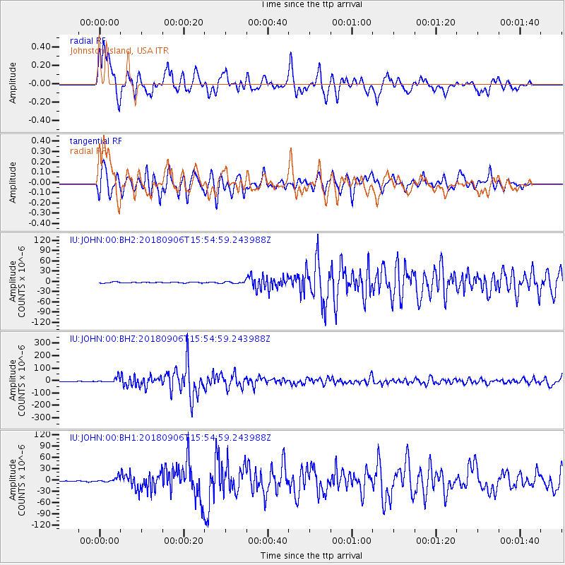
Signal To Noise
| Channel | StoN | STA | LTA |
| IU:JOHN:00:BHZ:20180906T15:54:59.243988Z | 18.39787 | 2.1178595E-5 | 1.151144E-6 |
| IU:JOHN:00:BH1:20180906T15:54:59.243988Z | 5.712469 | 6.443927E-6 | 1.1280458E-6 |
| IU:JOHN:00:BH2:20180906T15:54:59.243988Z | 2.2522137 | 2.9679832E-6 | 1.317807E-6 |
| Arrivals |
| Ps | 1.9 SECOND |
| PpPs | 6.7 SECOND |
| PsPs/PpSs | 8.5 SECOND |


