You are here: Home > Network List > CI - Caltech Regional Seismic Network Stations List
> Station BAR Barrett, Tecate, CA, USA > Earthquake Result Viewer
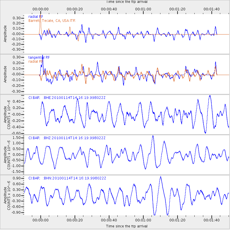
BAR Barrett, Tecate, CA, USA - Earthquake Result Viewer
*The percent match for this event was below the threshold and hence no stack was calculated.
| Earthquake location: |
South Of Mariana Islands |
| Earthquake latitude/longitude: |
11.5/142.1 |
| Earthquake time(UTC): |
2010/01/14 (014) 14:03:41 GMT |
| Earthquake Depth: |
37 km |
| Earthquake Magnitude: |
5.7 MB, 5.8 MS, 5.8 MW, 5.7 MW |
| Earthquake Catalog/Contributor: |
WHDF/NEIC |
|
| Network: |
CI Caltech Regional Seismic Network |
| Station: |
BAR Barrett, Tecate, CA, USA |
| Lat/Lon: |
32.68 N/116.67 W |
| Elevation: |
521 m |
|
| Distance: |
93.1 deg |
| Az: |
55.933 deg |
| Baz: |
285.683 deg |
| Ray Param: |
$rayparam |
*The percent match for this event was below the threshold and hence was not used in the summary stack. |
|
| Radial Match: |
67.54401 % |
| Radial Bump: |
400 |
| Transverse Match: |
62.862225 % |
| Transverse Bump: |
400 |
| SOD ConfigId: |
1 |
| Insert Time: |
2010-03-17 22:59:58.626 +0000 |
| GWidth: |
2.5 |
| Max Bumps: |
400 |
| Tol: |
0.001 |
|
Signal To Noise
| Channel | StoN | STA | LTA |
| CI:BAR: :BHZ:20100114T14:16:19.998022Z | 1.9895623 | 6.3473004E-7 | 3.1902997E-7 |
| CI:BAR: :BHN:20100114T14:16:19.998022Z | 1.058643 | 4.101164E-7 | 3.8739822E-7 |
| CI:BAR: :BHE:20100114T14:16:19.998022Z | 0.55806935 | 1.16611105E-7 | 2.089545E-7 |
| Arrivals |
| Ps | |
| PpPs | |
| PsPs/PpSs | |


