You are here: Home > Network List > CI - Caltech Regional Seismic Network Stations List
> Station EDW2 EDW2, Mojave, CA, USA > Earthquake Result Viewer
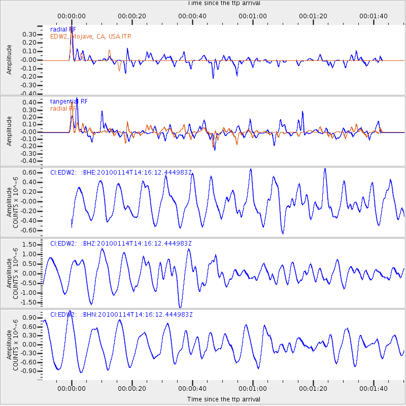
EDW2 EDW2, Mojave, CA, USA - Earthquake Result Viewer
*The percent match for this event was below the threshold and hence no stack was calculated.
| Earthquake location: |
South Of Mariana Islands |
| Earthquake latitude/longitude: |
11.5/142.1 |
| Earthquake time(UTC): |
2010/01/14 (014) 14:03:41 GMT |
| Earthquake Depth: |
37 km |
| Earthquake Magnitude: |
5.7 MB, 5.8 MS, 5.8 MW, 5.7 MW |
| Earthquake Catalog/Contributor: |
WHDF/NEIC |
|
| Network: |
CI Caltech Regional Seismic Network |
| Station: |
EDW2 EDW2, Mojave, CA, USA |
| Lat/Lon: |
34.88 N/117.99 W |
| Elevation: |
772 m |
|
| Distance: |
91.5 deg |
| Az: |
54.107 deg |
| Baz: |
285.025 deg |
| Ray Param: |
$rayparam |
*The percent match for this event was below the threshold and hence was not used in the summary stack. |
|
| Radial Match: |
61.23033 % |
| Radial Bump: |
385 |
| Transverse Match: |
84.36777 % |
| Transverse Bump: |
384 |
| SOD ConfigId: |
1 |
| Insert Time: |
2010-03-17 23:00:37.337 +0000 |
| GWidth: |
2.5 |
| Max Bumps: |
400 |
| Tol: |
0.001 |
|
Signal To Noise
| Channel | StoN | STA | LTA |
| CI:EDW2: :BHZ:20100114T14:16:12.444983Z | 0.8579019 | 5.1074534E-7 | 5.953424E-7 |
| CI:EDW2: :BHN:20100114T14:16:12.444983Z | 1.7799544 | 7.6977176E-7 | 4.3246712E-7 |
| CI:EDW2: :BHE:20100114T14:16:12.444983Z | 0.93324375 | 2.5116717E-7 | 2.6913352E-7 |
| Arrivals |
| Ps | |
| PpPs | |
| PsPs/PpSs | |


