You are here: Home > Network List > US - United States National Seismic Network Stations List
> Station MSO Missoula, Montana, USA > Earthquake Result Viewer
MSO Missoula, Montana, USA - Earthquake Result Viewer
*The percent match for this event was below the threshold and hence no stack was calculated.
| Earthquake location: |
Samoa Islands Region |
| Earthquake latitude/longitude: |
-16.9/-168.8 |
| Earthquake time(UTC): |
2022/09/14 (257) 05:08:06 GMT |
| Earthquake Depth: |
10 km |
| Earthquake Magnitude: |
6.0 Mi |
| Earthquake Catalog/Contributor: |
NEIC PDE/pt |
|
| Network: |
US United States National Seismic Network |
| Station: |
MSO Missoula, Montana, USA |
| Lat/Lon: |
46.83 N/113.94 W |
| Elevation: |
1264 m |
|
| Distance: |
80.3 deg |
| Az: |
34.712 deg |
| Baz: |
232.553 deg |
| Ray Param: |
$rayparam |
*The percent match for this event was below the threshold and hence was not used in the summary stack. |
|
| Radial Match: |
73.15527 % |
| Radial Bump: |
400 |
| Transverse Match: |
61.79182 % |
| Transverse Bump: |
400 |
| SOD ConfigId: |
28764291 |
| Insert Time: |
2022-09-28 05:43:53.640 +0000 |
| GWidth: |
2.5 |
| Max Bumps: |
400 |
| Tol: |
0.001 |
|
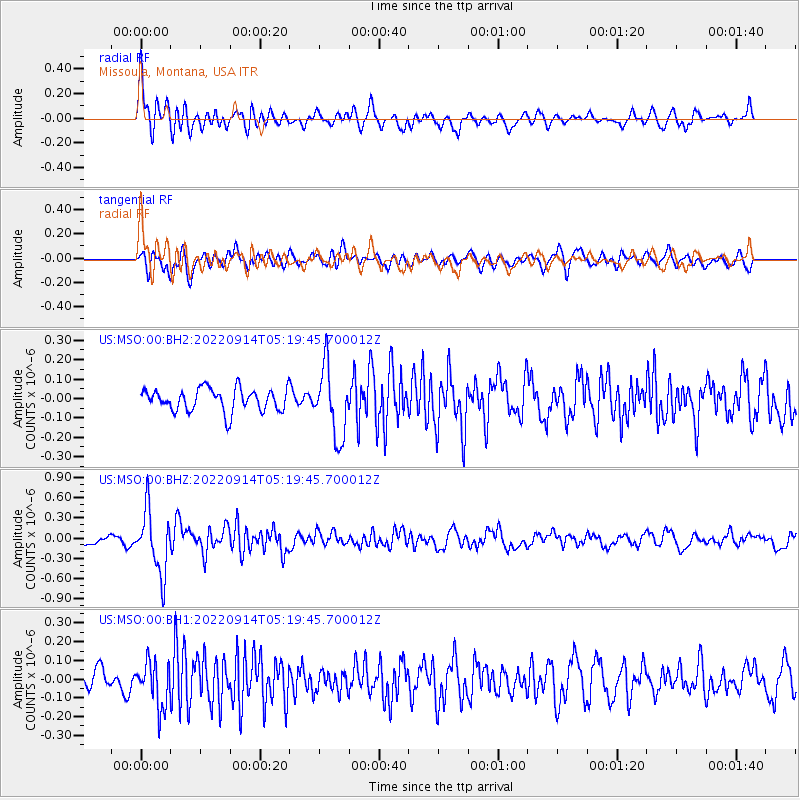
Signal To Noise
| Channel | StoN | STA | LTA |
| US:MSO:00:BHZ:20220914T05:19:45.700012Z | 7.5188694 | 4.6294474E-7 | 6.157106E-8 |
| US:MSO:00:BH1:20220914T05:19:45.700012Z | 2.0313601 | 1.1990612E-7 | 5.9027506E-8 |
| US:MSO:00:BH2:20220914T05:19:45.700012Z | 3.0979104 | 1.7956629E-7 | 5.796368E-8 |
| Arrivals |
| Ps | |
| PpPs | |
| PsPs/PpSs | |


