You are here: Home > Network List > US - United States National Seismic Network Stations List
> Station NLWA Neilton Lookout, Washington, USA > Earthquake Result Viewer
NLWA Neilton Lookout, Washington, USA - Earthquake Result Viewer
| Earthquake location: |
Fiji Islands |
| Earthquake latitude/longitude: |
-18.4/179.5 |
| Earthquake time(UTC): |
2018/09/06 (249) 15:49:17 GMT |
| Earthquake Depth: |
669 km |
| Earthquake Magnitude: |
8.1 Mi |
| Earthquake Catalog/Contributor: |
NEIC PDE/at |
|
| Network: |
US United States National Seismic Network |
| Station: |
NLWA Neilton Lookout, Washington, USA |
| Lat/Lon: |
47.39 N/123.87 W |
| Elevation: |
640 m |
|
| Distance: |
82.8 deg |
| Az: |
34.882 deg |
| Baz: |
233.055 deg |
| Ray Param: |
0.044527814 |
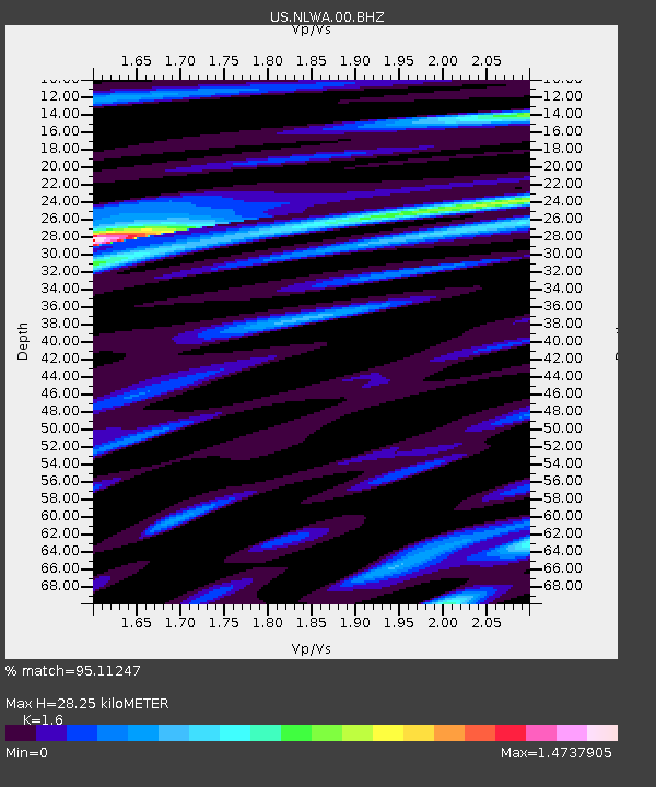
| Estimated Moho Depth: |
28.25 km |
| Estimated Crust Vp/Vs: |
1.60 |
| Assumed Crust Vp: |
6.566 km/s |
| Estimated Crust Vs: |
4.104 km/s |
| Estimated Crust Poisson's Ratio: |
0.18 |
|
| Radial Match: |
95.11247 % |
| Radial Bump: |
400 |
| Transverse Match: |
95.79808 % |
| Transverse Bump: |
400 |
| SOD ConfigId: |
2825771 |
| Insert Time: |
2018-09-20 15:58:43.051 +0000 |
| GWidth: |
2.5 |
| Max Bumps: |
400 |
| Tol: |
0.001 |
|
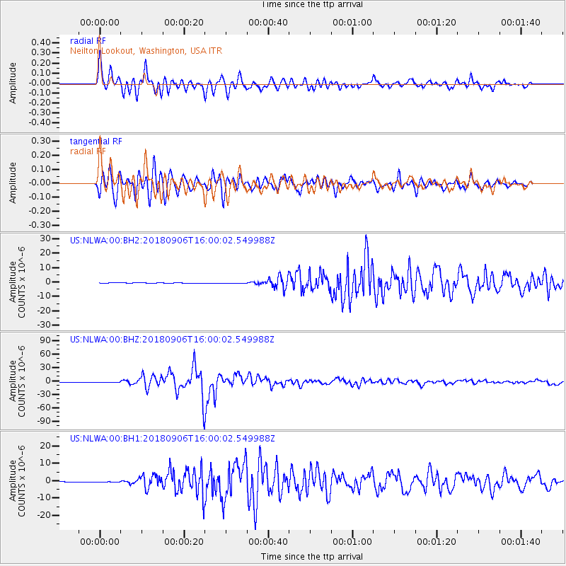
Signal To Noise
| Channel | StoN | STA | LTA |
| US:NLWA:00:BHZ:20180906T16:00:02.549988Z | 3.7640858 | 5.6663464E-7 | 1.5053712E-7 |
| US:NLWA:00:BH1:20180906T16:00:02.549988Z | 1.5595702 | 1.4579555E-7 | 9.348445E-8 |
| US:NLWA:00:BH2:20180906T16:00:02.549988Z | 1.6257954 | 1.6758622E-7 | 1.0307953E-7 |
| Arrivals |
| Ps | 2.7 SECOND |
| PpPs | 11 SECOND |
| PsPs/PpSs | 14 SECOND |


