You are here: Home > Network List > 1E - GSC-BCOGC Induced Seismicity Study Stations List
> Station BCH2A Z > Earthquake Result Viewer
BCH2A Z - Earthquake Result Viewer
| Earthquake location: |
Southeast Of Loyalty Islands |
| Earthquake latitude/longitude: |
-21.2/170.1 |
| Earthquake time(UTC): |
2022/09/14 (257) 11:04:07 GMT |
| Earthquake Depth: |
124 km |
| Earthquake Magnitude: |
7.0 Mi |
| Earthquake Catalog/Contributor: |
NEIC PDE/at |
|
| Network: |
1E GSC-BCOGC Induced Seismicity Study |
| Station: |
BCH2A Z |
| Lat/Lon: |
55.95 N/120.36 W |
| Elevation: |
761 m |
|
| Distance: |
96.5 deg |
| Az: |
32.041 deg |
| Baz: |
241.643 deg |
| Ray Param: |
0.040388666 |
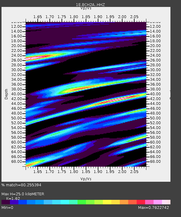
| Estimated Moho Depth: |
25.0 km |
| Estimated Crust Vp/Vs: |
1.62 |
| Assumed Crust Vp: |
6.303 km/s |
| Estimated Crust Vs: |
3.89 km/s |
| Estimated Crust Poisson's Ratio: |
0.19 |
|
| Radial Match: |
80.255394 % |
| Radial Bump: |
400 |
| Transverse Match: |
60.968014 % |
| Transverse Bump: |
400 |
| SOD ConfigId: |
28764291 |
| Insert Time: |
2022-09-28 11:06:08.090 +0000 |
| GWidth: |
2.5 |
| Max Bumps: |
400 |
| Tol: |
0.001 |
|

Signal To Noise
| Channel | StoN | STA | LTA |
| 1E:BCH2A: :HHZ:20220914T11:16:51.109985Z | 8.452825 | 1.166533E-6 | 1.3800512E-7 |
| 1E:BCH2A: :HHN:20220914T11:16:51.109985Z | 2.2331922 | 2.4418117E-7 | 1.09341755E-7 |
| 1E:BCH2A: :HHE:20220914T11:16:51.109985Z | 3.144405 | 2.8591688E-7 | 9.092877E-8 |
| Arrivals |
| Ps | 2.5 SECOND |
| PpPs | 10 SECOND |
| PsPs/PpSs | 13 SECOND |


