You are here: Home > Network List > AK - Alaska Regional Network Stations List
> Station K15K Wolf Creek Mountain, AK, USA > Earthquake Result Viewer
K15K Wolf Creek Mountain, AK, USA - Earthquake Result Viewer
| Earthquake location: |
Southeast Of Loyalty Islands |
| Earthquake latitude/longitude: |
-21.2/170.1 |
| Earthquake time(UTC): |
2022/09/14 (257) 11:04:07 GMT |
| Earthquake Depth: |
124 km |
| Earthquake Magnitude: |
7.0 Mi |
| Earthquake Catalog/Contributor: |
NEIC PDE/at |
|
| Network: |
AK Alaska Regional Network |
| Station: |
K15K Wolf Creek Mountain, AK, USA |
| Lat/Lon: |
62.29 N/161.53 W |
| Elevation: |
346 m |
|
| Distance: |
86.2 deg |
| Az: |
12.86 deg |
| Baz: |
206.382 deg |
| Ray Param: |
0.04394037 |
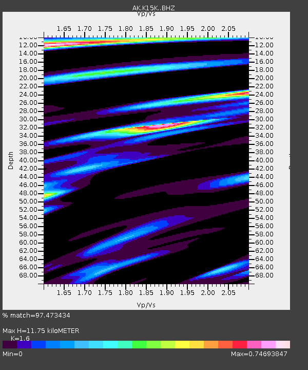
| Estimated Moho Depth: |
11.75 km |
| Estimated Crust Vp/Vs: |
1.60 |
| Assumed Crust Vp: |
6.276 km/s |
| Estimated Crust Vs: |
3.922 km/s |
| Estimated Crust Poisson's Ratio: |
0.18 |
|
| Radial Match: |
97.473434 % |
| Radial Bump: |
301 |
| Transverse Match: |
89.71898 % |
| Transverse Bump: |
398 |
| SOD ConfigId: |
28764291 |
| Insert Time: |
2022-09-28 11:09:11.049 +0000 |
| GWidth: |
2.5 |
| Max Bumps: |
400 |
| Tol: |
0.001 |
|

Signal To Noise
| Channel | StoN | STA | LTA |
| AK:K15K: :BHZ:20220914T11:16:03.380005Z | 80.98273 | 7.834439E-6 | 9.6742106E-8 |
| AK:K15K: :BHN:20220914T11:16:03.380005Z | 26.704264 | 2.60778E-6 | 9.7654066E-8 |
| AK:K15K: :BHE:20220914T11:16:03.380005Z | 17.987082 | 1.9197846E-6 | 1.0673131E-7 |
| Arrivals |
| Ps | 1.2 SECOND |
| PpPs | 4.8 SECOND |
| PsPs/PpSs | 5.9 SECOND |


